
Why Avoid Tolls on Google Maps?
When planning a journey, using Google Maps is almost second nature to most of us. This powerful tool not only helps us navigate unknown roads but also provides information on the fastest and most efficient routes. However, sometimes we may want to avoid toll roads for a variety of reasons. Whether you’re trying to save money, have a more scenic drive, or simply prefer to avoid toll booths and traffic, Google Maps can be customized to cater to your specific needs.
Avoiding tolls on Google Maps can save you a significant amount of money, especially if you frequently travel on highways with tolls. Toll costs can quickly add up, especially on long-distance journeys, making it a sensible choice for those on a budget. Additionally, toll-free routes often provide scenic drives, allowing you to enjoy the beauty of the surrounding landscapes without the distractions of toll booths and high-speed highways.
Furthermore, opting to avoid toll roads can sometimes result in faster travel times. While toll roads are generally well-maintained and offer fewer traffic disruptions, they are also more commonly traveled. As a result, choosing alternative routes can help you bypass heavy congestion and reach your destination more efficiently, particularly during peak travel periods.
For some drivers, the desire to avoid toll roads may come from a simple preference to take the road less traveled. Exploring lesser-known roads can provide a sense of adventure and discovery, allowing you to stumble upon hidden gems and unique experiences along the way. By avoiding the main toll routes, you may stumble upon charming towns, beautiful landscapes, and interesting landmarks.
Using the “Avoid Tolls” Option in Google Maps
Google Maps makes it incredibly easy to avoid tolls on your routes. By following a few simple steps, you can ensure that you are directed along toll-free roads, providing you with a more cost-effective and enjoyable journey.
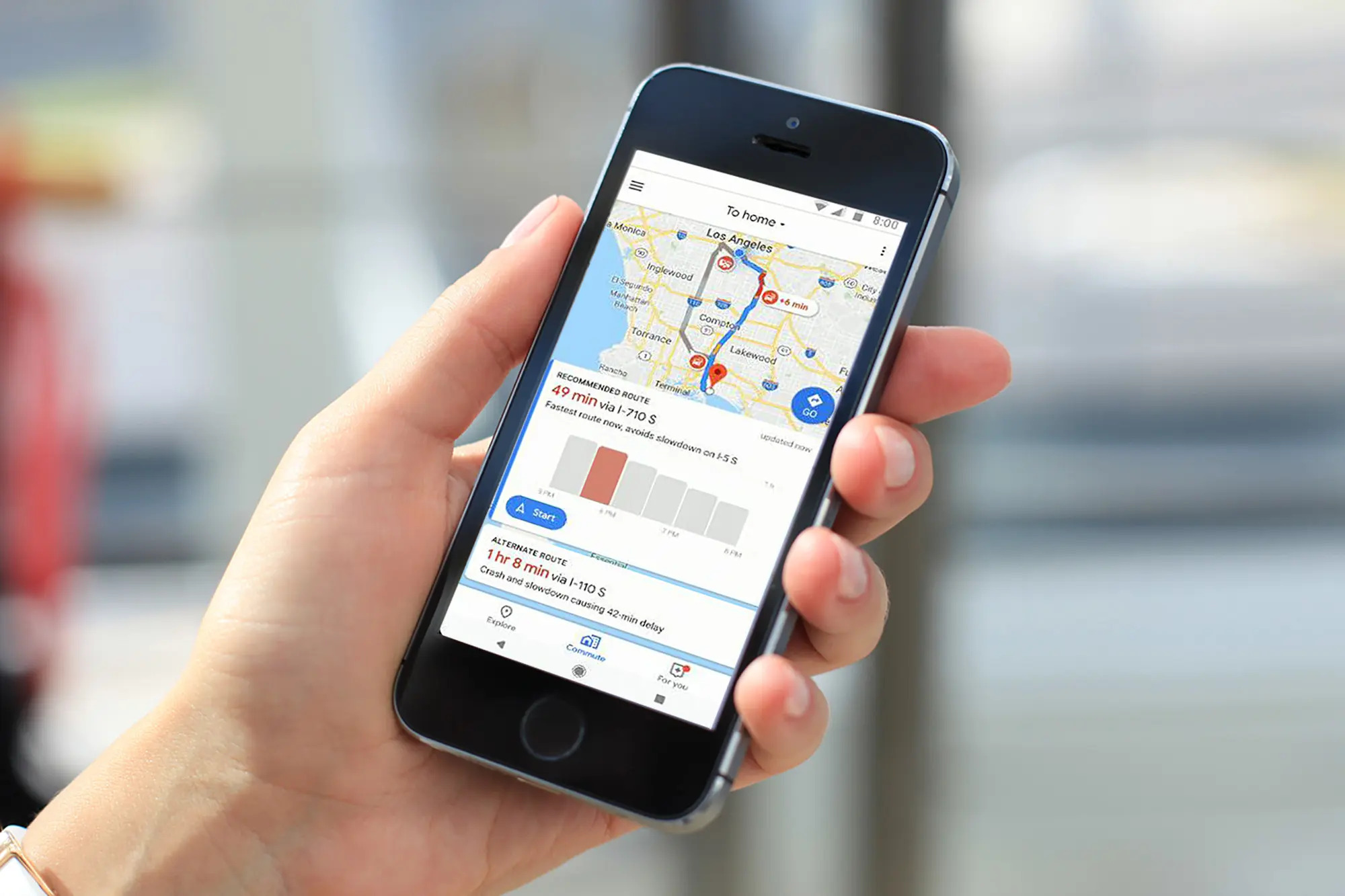
To start, open the Google Maps app on your smartphone or visit the Google Maps website on your computer. Enter your starting point and destination just as you would for any other route. Once the suggested route is displayed, look for the three vertical dots in the top right corner of the screen.
Clicking on these three dots will open a drop-down menu with various options. Look for the “Route Options” or “Route Settings” tab and tap on it. Here, you will find the “Avoid tolls” option. By selecting this option, Google Maps will automatically recalculate your route to avoid any toll roads or bridges along the way.
It’s important to note that when you enable the “Avoid tolls” option, your route may be slightly longer in terms of distance or travel time. However, this will ensure that you are not charged any tolls during your journey.
Once you have enabled the “Avoid tolls” option, simply click or tap on “Done” to generate your new toll-free route. Google Maps will provide you with turn-by-turn directions along the modified route, ensuring that you reach your destination while avoiding any toll roads or bridges along the way.
Remember, the “Avoid tolls” option is not limited to individual trips. You can also set this preference as your default setting for all future trips. This means that every time you plan a route using Google Maps, it will automatically generate toll-free options without you needing to manually select the “Avoid tolls” option each time.
By utilizing the “Avoid tolls” option in Google Maps, you can easily customize your routes to suit your preferences and budget. So the next time you’re planning a journey, take advantage of this feature and enjoy a hassle-free, toll-free travel experience.
Choosing Alternative Routes
When it comes to avoiding tolls on Google Maps, one of the most effective strategies is to choose alternative routes. By exploring different road options, you can uncover hidden gems, take scenic detours, and save money on toll fees. Here’s how you can find and select alternative routes on Google Maps.
When planning your route, allow Google Maps to generate the fastest or default route first. This will give you a baseline to work with. Once the initial route is displayed, closely examine the map. Look for parallel roads, highways, or local streets that run parallel to the toll roads on your route.
Identify the alternative route that appears to be the most suitable based on your preferences. This could be a scenic countryside road, a coastal highway, or a less congested urban route.
Once you’ve identified the alternative route, tap on the road to select it. A new pop-up window will appear with route details, including the estimated travel time and distance. Review this information to ensure that the alternative route is feasible and meets your specific needs.
If the alternative route is satisfactory, simply follow the on-screen instructions to select it as your preferred route. Google Maps will then recalculate your journey, providing turn-by-turn directions along the chosen alternative road.
Keep in mind that alternative routes may not always be the fastest in terms of travel time. They may take longer due to lower speed limits or increased traffic flow. Consider the trade-off between avoiding tolls and spending more time on the road.
It’s worth mentioning that alternative routes can also be helpful when you encounter unexpected traffic or road closures on the main toll roads. In such situations, using Google Maps to quickly switch to an alternate route can help you avoid delays and reach your destination more efficiently.
Navigating Through Shortcut Roads
One effective strategy for avoiding tolls on Google Maps is to navigate through shortcut roads. These are smaller, local roads that can help you bypass toll roads and save money. Here are some tips for finding and navigating through shortcut roads using Google Maps.
When planning your route on Google Maps, pay attention to the suggested roads and highways that you will be traveling on. Look for any smaller, alternative roads that run parallel to the main toll roads. These are often labeled as local streets or back roads on the map.
To explore these shortcut roads, zoom in on the map and tap on the specific road or street that catches your attention. A pop-up window will appear with more details about that road, such as the road name and any intersecting streets. Use this information to determine if the shortcut road is a viable option for your journey.
If the shortcut road seems suitable, select it as part of your route by tapping on it or dragging the route line to pass through that road. Google Maps will then recalculate your route, providing you with new turn-by-turn directions that include the chosen shortcut road.
Shortcut roads can provide a more local and authentic experience, allowing you to explore different neighborhoods and possibly discover hidden gems along the way. However, keep in mind that these roads may not always be well-maintained or have the same level of infrastructure as the main toll roads. Consider the trade-off between saving money and potentially encountering rough or less-traveled roads.
Additionally, be aware that shortcut roads may add some extra time to your overall travel time. While these roads can help you avoid tolls, they could be slower due to factors such as lower speed limits or increased traffic flow. Evaluate the trade-off between saving money and spending more time on the road.
It’s important to note that navigating through shortcut roads requires being attentive and following the directions provided by Google Maps. Pay close attention to the turn-by-turn instructions to ensure you stay on the designated route and reach your destination safely.
By leveraging the power of Google Maps, you can easily navigate through shortcut roads and avoid tolls, creating a more customized and economical travel experience.
Adjusting Departure Time
Another helpful strategy for avoiding tolls on Google Maps is adjusting your departure time. By changing when you start your journey, you can potentially bypass peak traffic periods and choose routes with fewer toll roads. Here’s how you can use Google Maps to optimize your departure time.
When planning your trip on Google Maps, input your desired destination and select the date and time you wish to depart. Once you have entered this information, Google Maps will generate the suggested route, taking into account current traffic conditions.
Take a close look at the estimated travel time displayed on the map. This will vary depending on the time of day, as traffic conditions fluctuate throughout the day. If the suggested travel time is long or includes several toll roads, consider adjusting your departure time to avoid peak traffic hours.
Experiment with different departure times by moving the time slider on Google Maps. This will update the suggested route and display the estimated travel time for each time slot. Look for time slots that offer shorter travel times or fewer tolls on the route.
Choosing an earlier or later departure time can help you avoid rush hour traffic, when toll roads are often congested. By shifting your departure time, you may be able to take advantage of less crowded roads and potentially reduce the number of tolls you encounter.
Keep in mind that adjusting your departure time may have other implications, such as encountering different traffic patterns or facing peak traffic in other areas. Evaluate the overall trade-off between avoiding tolls and finding a departure time that offers the most efficient and pleasant travel experience.
By using the flexibility of Google Maps to adjust your departure time, you can increase your chances of finding routes with fewer tolls and smoother traffic conditions, resulting in a more cost-effective and enjoyable journey.
Saving Routes for Future Use
Google Maps offers a convenient feature that allows you to save and access routes for future use. This can be particularly helpful when you want to avoid tolls on a regular basis. By saving customized routes, you can quickly access toll-free alternatives without the need to manually input the details each time. Here’s how you can save routes on Google Maps.
After generating a route on Google Maps, ensure that the “Avoid tolls” option is selected if you want to find a toll-free route. Once you have confirmed the route and are viewing it on the map, click or tap on the “Save” button located at the bottom of the screen. You may need to click the arrow icon to reveal additional options if the “Save” button is not immediately visible.
A window will then appear, allowing you to customize and name the saved route. Give the route a recognizable and descriptive name, such as “Work Commute” or “Toll-Free Road Trip.” You can also add additional notes or details to help you remember the purpose of the saved route.
Once you have named and saved the route, it will be accessible in the saved routes section of your Google Maps account. When you want to use the saved route in the future, simply open Google Maps and go to the side menu. Look for the “Saved” or “Your places” option, where you will find your saved routes.
By tapping on the saved route, Google Maps will generate the toll-free alternative for you. This eliminates the need to manually select the “Avoid tolls” option and input the route details each time you want to use it.
Saving routes for future use is not limited to one-time trips. You can save different routes for various purposes, such as daily commutes, weekend getaways, or city tours. This allows you to easily switch between routes and access the most relevant toll-free alternatives whenever needed.
By taking advantage of the route-saving feature in Google Maps, you can efficiently plan and access toll-free routes for future use. This not only saves time and effort but also ensures a smooth and enjoyable travel experience without the inconvenience of toll booths and fees.
Using Incognito Mode for Toll-free Routes
Did you know that using Incognito mode in your web browser can help you find toll-free routes on Google Maps? By opening Google Maps in Incognito mode, you can access routes without any influence from your past search history or personalized preferences. Here’s how you can use Incognito mode to find toll-free routes.
To open Google Maps in Incognito mode, launch your preferred web browser and look for the three-dot menu icon in the top right corner. Click or tap on this icon to reveal a dropdown menu, where you will find an option for “New Incognito Window” or “New Private Window.”
Clicking on this option will open a new window specifically for Incognito mode. In this mode, Google Maps will not save your search history or make personalized route suggestions based on your previous searches.
In the Incognito mode window, navigate to the Google Maps website and enter your starting point and destination as you normally would. Google Maps will generate a fresh set of suggestions without taking into account your past searches or preferences.
After generating the suggested route, carefully review it to identify any toll roads or bridges along the way. If the route includes tolls and you want to find a toll-free alternative, you can manually explore various roads and highways on the map to identify potential alternatives.
By using Google Maps in Incognito mode, you ensure that your search history and personalized preferences do not influence the suggested routes. This allows you to explore toll-free options without any biases based on previous searches or routing preferences.
Keep in mind that using Incognito mode only affects your browsing experience within that specific Incognito window. It does not impact your regular browsing sessions or personalized settings.
Using Incognito mode for finding toll-free routes on Google Maps is a useful strategy for those who want to ensure unbiased and unbiased route suggestions. It can be particularly helpful when you want to discover alternatives without any influence from your past searches or preferences.
Getting Real-time Traffic Updates
Staying up to date with real-time traffic updates is crucial when trying to avoid toll roads on Google Maps. By having access to the most current traffic information, you can make informed decisions about which routes to take and navigate around any potential congestion or delays. Here’s how you can get real-time traffic updates on Google Maps.
When planning your route on Google Maps, pay attention to the color-coded lines on the map that indicate traffic conditions. Green lines represent free-flowing traffic, yellow lines indicate moderate traffic congestion, and red lines signify heavy traffic or standstill conditions.
By observing the color-coded lines, you can quickly get an overview of the traffic conditions along your route. Avoiding toll roads becomes easier, as you can choose alternative routes that have a lighter traffic load and fewer delays.
In addition to the color-coded lines, Google Maps also provides spoken traffic alerts while you are using the navigation feature. This includes real-time updates on accidents, road construction, or other incidents that may impact your route. Pay attention to these alerts and follow the suggested detours to bypass any traffic disruptions.
It’s also helpful to enable notifications from the Google Maps app on your smartphone. This way, you can receive proactive traffic updates even when you are not actively using the app. This can be especially valuable if you are on the move and need to make quick decisions about which route to take in order to avoid toll roads and heavy traffic.
Lastly, take advantage of the “traffic” layer feature on Google Maps. By selecting this option, you can view real-time traffic conditions displayed as color-coded overlays on the map. This can help you identify areas of heavy traffic and plan alternative routes accordingly.
Remember that traffic conditions are dynamic and can change rapidly. It’s important to continuously monitor the traffic updates provided by Google Maps to ensure you have the most accurate and up-to-date information. This will enable you to make real-time adjustments to your route and choose toll-free options that will help you reach your destination efficiently.
By utilizing the real-time traffic updates on Google Maps, you can navigate around toll roads and avoid traffic congestion, ensuring a smoother and more stress-free travel experience.
Opting for Public Transportation
Another effective way to avoid tolls on Google Maps is to utilize public transportation options. Many cities and regions have extensive public transportation networks that can help you reach your destination without the need to drive on toll roads. Here’s how you can opt for public transportation using Google Maps.
Once you have entered your starting point and destination on Google Maps, take a look at the available transportation options presented to you. Alongside driving directions, you will see icons representing public transit options such as buses, trains, or subways.
Click or tap on the public transit option that is most convenient for you. Google Maps will provide you with details about the nearest public transportation stations, bus stops, or train routes that can take you to your destination.
Note the estimated travel time and any transfers you may need to make. Public transportation is often a reliable and cost-effective alternative, but it may require some additional time for waiting and transfers compared to driving.
Consider the convenience of public transportation, especially if you are traveling to a congested city center or popular tourist area where parking can be expensive or limited. Public transportation can provide a hassle-free and environmentally friendly way to reach your destination.
If you opt for public transportation, Google Maps will provide you with step-by-step instructions on how to navigate the transit system. This may include walking directions to the nearest station, information on the correct bus or train to board, and even real-time updates on delays or schedule changes.
Using public transportation not only helps you avoid toll roads but can also alleviate the stress of driving in congested areas. You can sit back, relax, and enjoy the scenery while leaving the navigation and traffic to the public transportation system.
Before you embark on your journey, make sure to check the schedules and operating hours of the public transportation system. This will help you plan your departure and arrival times accordingly.
By opting for public transportation, you can experience a more cost-effective, efficient, and eco-friendly way to navigate through urban areas. Google Maps makes it easy to incorporate public transit options into your travel plans, allowing you to effortlessly avoid tolls and enjoy the benefits of accessible and reliable public transportation networks.
Checking for Toll Road Alternatives on Google Earth
Google Earth is a powerful tool that can assist you in finding toll road alternatives and exploring various routes in a more visual and immersive way. By utilizing Google Earth alongside Google Maps, you can gain a better understanding of the road network and discover potential toll-free alternatives for your journeys. Here’s how you can check for toll road alternatives on Google Earth.
Start by opening Google Earth on your computer or mobile device. Navigate to the area or region where you want to check for toll road alternatives.
As you zoom in on the map, pay attention to the roads and highways that are displayed. Toll roads are often clearly labeled or marked with specific indicators, such as a toll booth icon or markers denoting toll road sections.
Identify the toll road or toll road sections that you want to avoid. Look for alternative routes that run parallel or intersect with the toll road. These roads may be labeled as local streets, back roads, or state routes.
Use Google Earth’s Street View feature to virtually explore the alternative routes. This can provide you with a more realistic and detailed view of the roads, allowing you to assess their condition, traffic density, and suitability for your journey.
By visually examining the alternative routes on Google Earth, you can evaluate their potential benefits, such as scenic views, interesting landmarks, or opportunities to bypass toll booths and heavy traffic areas.
Remember to cross-reference the toll-free alternatives found on Google Earth with the directions provided by Google Maps. This will ensure that the selected routes are practical, accurately mapped, and aligned with your intended destination.
Additionally, keep in mind that Google Earth provides a more comprehensive and detailed view of the road network but may not always reflect real-time traffic conditions. For up-to-date traffic information, rely on Google Maps or other traffic monitoring services.
By combining the visual capabilities of Google Earth with the precise directions of Google Maps, you can efficiently explore toll-free alternatives, find scenic routes, and make informed decisions about which roads to take on your journeys.
Using Google Earth as a supplementary tool alongside Google Maps can enhance your route planning process and lead you to discover exciting and toll-free roads that you may have otherwise missed.