
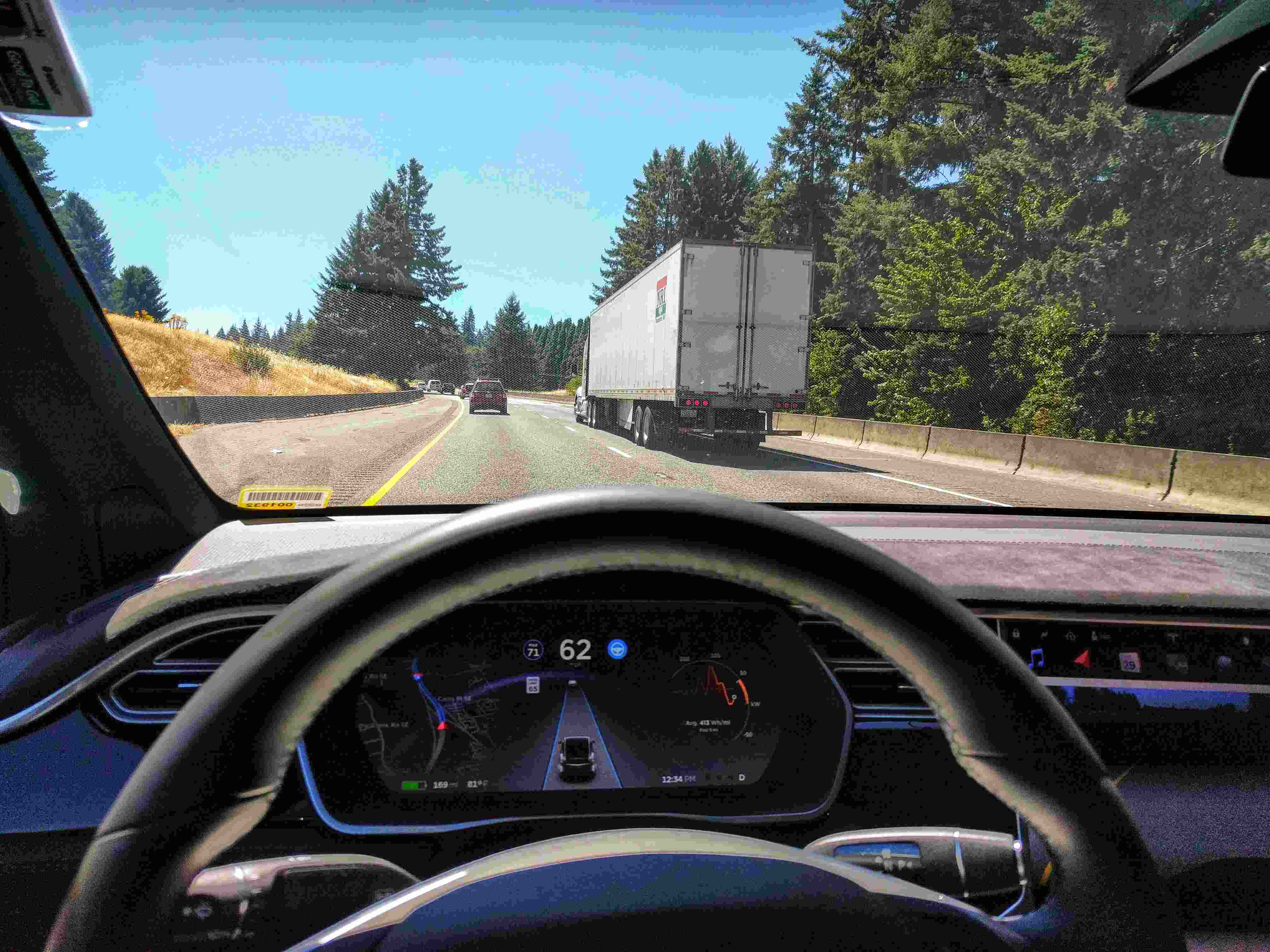
What is Lane Centering?
Lane centering is a cutting-edge technology that is revolutionizing the way we drive. It is an advanced driver-assistance system (ADAS) feature designed to help drivers keep their vehicles safely within the lanes on the road. Unlike lane departure warning systems that only alert the driver when they drift out of their lane, lane centering takes proactive measures to actively steer the vehicle back into the center of the lane.
Lane centering systems utilize various sensors and intelligent algorithms to continuously monitor the position of the vehicle within its lane. By analyzing the lane markings or nearby objects, these systems provide subtle steering interventions to ensure the vehicle stays centered in its lane.
This technology not only enhances safety but also adds convenience and reduces driver fatigue. By automatically adjusting the steering, lane centering allows drivers to focus more on their surroundings and reduces the risk of accidents caused by lane drifting or inadequate steering control.
Lane centering systems are usually found in modern vehicles as part of a suite of advanced driver-assistance systems. They work hand in hand with other features such as adaptive cruise control, lane keeping assist, and collision warning systems to provide a comprehensive safety package.
It is important to note that lane centering is not a fully autonomous driving system. While it assists the driver in maintaining the vehicle’s position within the lane, the driver is still responsible for actively steering the vehicle and remaining attentive at all times.
The implementation of lane centering technology varies among different vehicle manufacturers, but the underlying goal remains the same – to improve road safety and provide a smoother driving experience.
How Does Lane Centering Work?
Lane centering systems employ a combination of sensor technology and sophisticated algorithms to function effectively. Here’s a closer look at how these systems work:
Sensor Technology: Lane centering systems primarily rely on sensor inputs to gather real-time data about the vehicle’s position and its surroundings. The most common sensors used include cameras, radar, lidar, and GPS receivers.
Camera-Based Systems: Visual-based lane centering systems use cameras mounted on the vehicle to capture images of the road and lane markings. These images are then processed using computer vision algorithms to detect and track the lane markers.
GPS-Based Systems: Some lane centering systems incorporate GPS receivers to determine the vehicle’s precise location on the road. By comparing the GPS data with digital map information, these systems can estimate the vehicle’s position within the lane.
Lidar-Based Systems: Lidar, which stands for Light Detection and Ranging, uses laser beams to measure the distance and create a detailed 3D map of the vehicle’s surroundings. Lidar-based lane centering systems utilize this map to detect and follow lane markings accurately.
Radar-Based Systems: Radar sensors emit radio waves and measure their reflections to detect and track objects around the vehicle. Radar-based lane centering systems leverage this technology to identify lane markers and provide precise steering interventions.
Identification of Lane Markings: Once the sensors collect the necessary data, lane centering systems need to identify the lane markings accurately. This process involves performing image analysis, pattern recognition, or machine learning techniques on the sensor data to differentiate between lane markers and other objects.
Edge Detection Algorithms: Lane centering systems utilize edge detection algorithms to identify the distinct edges of the lane markings. This allows the system to determine the position and trajectory of the vehicle relative to the lane center.
Road Object Detection: In addition to lane markings, lane centering systems may also detect and track objects such as vehicles, pedestrians, or obstacles near the vehicle’s path. This information helps enhance the system’s ability to make efficient steering interventions and avoid potential hazards.
Sensor Technology Used in Lane Centering Systems
Lane centering systems rely on a combination of advanced sensor technologies to accurately detect and respond to the vehicle’s position within the lane. These sensors provide real-time data to enable the system to make informed decisions and ensure precise steering interventions. Here are the primary sensor technologies used in lane centering systems:
1. Cameras: Camera-based systems are the most common sensors used in lane centering. These cameras, typically mounted on the front windshield or side mirrors, capture images of the road and lane markings. Through sophisticated computer vision algorithms, these systems analyze the images to identify the lane boundaries and the vehicle’s position within the lane. Camera sensors are cost-effective and provide high-resolution visuals, making them an integral part of most lane centering systems.
2. Radar: Radar sensors use radio waves to detect objects and estimate their distance and speed. In lane centering systems, radar sensors help identify the lane markings by detecting the edges of the lanes. These sensors emit radio waves and measure their reflections from the road surfaces to determine the position of the lane boundaries. Radar sensors can work effectively in various weather conditions, making them suitable for reliable lane detection and tracking.
3. Lidar: Lidar, which stands for Light Detection and Ranging, utilizes laser beams to measure distances and create a detailed 3D map of the surrounding environment. Lidar sensors are increasingly being used in advanced lane centering systems as they provide highly accurate depth perception and object detection capabilities. By scanning the road surface, lidar sensors can precisely detect and track lane markings, even in low visibility situations.
4. GPS Receivers: Global Positioning System (GPS) receivers can be utilized in lane centering systems to determine the vehicle’s precise location on the road. By comparing the GPS data with digital map information, these systems can estimate the vehicle’s position within the lane. While GPS is not as accurate as other sensor technologies for lane detection, it can supplement the system’s capabilities, especially in areas with limited or degraded lane markings.
5. Ultrasonic Sensors: Ultrasonic sensors emit sound waves and measure their reflections to detect objects in the vehicle’s proximity. While not as commonly used as other sensor technologies, ultrasonic sensors can provide additional information to lane centering systems for obstacles detection, especially during low-speed maneuvers.
The combination of these sensor technologies enables lane centering systems to gather crucial data about the vehicle’s position and surroundings, ensuring accurate lane detection and effective steering interventions. Manufacturers often integrate multiple sensor technologies to enhance the system’s robustness and reliability in different driving conditions.
Visual-based Lane Centering Systems
Visual-based lane centering systems utilize cameras mounted on the vehicle to capture real-time images of the road and lane markings. These camera sensors play a crucial role in detecting and tracking the lane boundaries, allowing the system to make accurate steering interventions. Here’s how visual-based lane centering systems work:
1. Image Capture: The cameras continuously capture images of the road ahead. Multiple cameras may be used to provide a comprehensive view of the surroundings, including the lanes and any potential obstacles.
2. Image Processing: The captured images are then processed using advanced computer vision algorithms. These algorithms analyze the images to detect and track the lane markings. They identify the distinct edges of the lanes and calculate the position of the vehicle relative to the lane center.
3. Lane Tracking: Once the lane markings are detected, the lane centering system determines the appropriate steering interventions to keep the vehicle centered within the lane. It uses the information from the camera sensors to adjust the steering angle accordingly.
4. Steering Interventions: The visual-based lane centering system provides subtle steering interventions to guide the vehicle back toward the center of the lane whenever it detects the vehicle deviating from the intended path. These interventions can include small adjustments to the steering angle, helping the driver maintain proper lane position.
5. Redundancy and Reliability: Visual-based lane centering systems often incorporate redundant camera sensors to enhance reliability. Multiple cameras provide a wider field of view and reduce the risk of blind spots, ensuring accurate lane detection and tracking. Additionally, some systems may incorporate artificial intelligence and machine learning techniques to improve the system’s accuracy over time.
Visual-based lane centering systems offer several advantages. They are cost-effective compared to other sensor technologies like lidar or radar. They also work well in a variety of driving conditions, including urban environments with complex road markings or rural areas with faded or worn-out lane markers. Their ability to capture high-resolution images allows for precise lane detection and reliable steering interventions.
However, visual-based systems can be more susceptible to environmental factors such as poor lighting conditions or adverse weather. Fog, rain, or glare can affect the quality of the captured images, potentially impacting the system’s accuracy. Manufacturers address this challenge by introducing advanced camera sensors with improved low-light performance and employing robust image processing algorithms to handle various weather conditions.
Visual-based lane centering systems continue to advance, leveraging machine learning and artificial intelligence to enhance their performance. These systems play a crucial role in promoting safer and more efficient driving, providing drivers with an additional layer of assistance in maintaining proper lane position.
GPS-based Lane Centering Systems
GPS-based lane centering systems utilize Global Positioning System (GPS) receivers to determine the vehicle’s precise location on the road. By integrating GPS data with digital maps, these systems can estimate the vehicle’s position within the lane and provide steering interventions to maintain proper lane alignment. Here’s how GPS-based lane centering systems work:
1. GPS Signal Reception: The GPS receiver on the vehicle receives signals from multiple satellites orbiting the Earth. These signals contain timing and positioning information.
2. Location Estimation: By analyzing the timing differences between the received signals, the GPS receiver can calculate the vehicle’s position on Earth with high accuracy. This includes latitude, longitude, and altitude.
3. Digital Map Comparison: GPS-based lane centering systems compare the GPS-derived position with detailed digital maps that contain lane information. These maps specify the geometry, boundaries, and additional lane-related attributes, aiding in accurate lane detection and tracking.
4. Lane Positioning: Using the digital map information, the system calculates the vehicle’s position within the lane. It determines the distance between the vehicle and the lane boundaries, as well as the relative position to the lane centerline.
5. Steering Interventions: GPS-based lane centering systems continuously monitor the vehicle’s position relative to the lane centerline. If the system detects the vehicle deviating from the center, it provides steering interventions to guide the vehicle back towards the desired lane position.
6. Map Updates: To ensure real-time accuracy, GPS-based lane centering systems rely on updated map data. Manufacturers often provide regular map updates to account for changes in road configurations, construction zones, or updates to lane markings.
GPS-based lane centering systems offer several advantages. They are effective in areas with clear visibility of satellite signals, making them suitable for highway driving or open road conditions. These systems can also contribute to improved lane detection and tracking accuracy in areas with faded or degraded lane markings.
However, GPS-based systems have limitations. They can experience reduced accuracy in densely built-up urban areas where tall buildings obstruct satellite signals or in areas with limited satellite coverage such as tunnels or deep valleys. Additionally, GPS-based lane centering systems may not be able to detect temporary or new road markings that are not yet updated in the digital maps.
Manufacturers are continuously improving GPS-based lane centering systems by integrating them with other sensor technologies such as cameras or radar. This sensor fusion approach enhances the system’s robustness, allowing for more reliable and accurate lane centering capabilities.
Overall, GPS-based lane centering systems provide valuable assistance in maintaining proper lane position. By leveraging the power of GPS technology and digital maps, these systems contribute to safer and more comfortable driving experiences on the road.
Lidar-based Lane Centering Systems
Lidar-based lane centering systems utilize Light Detection and Ranging (lidar) technology to accurately detect and track lane boundaries. Lidar sensors emit laser beams that bounce off objects, creating a detailed 3D map of the environment. These systems leverage lidar data to provide precise steering interventions and maintain proper lane alignment. Here’s how lidar-based lane centering systems work:
1. Laser Emission: Lidar sensors emit laser beams, typically in the form of rapid pulses, that sweep across the surrounding environment. The emitted lasers are of a specific wavelength, allowing them to interact with objects and reflect back to the sensor.
2. Laser Reflection: The laser beams interact with objects in the environment, including lane markings, and reflect back to the lidar sensor. The sensor measures the time it takes for the laser beams to return, allowing it to calculate the distance to each object.
3. 3D Mapping: By capturing multiple reflections from different laser pulses, the lidar sensor creates a highly accurate 3D map of the surroundings. This map includes detailed information about the geometry and position of objects, including lane markings.
4. Lane Marking Detection: Lidar-based lane centering systems analyze the 3D map data to detect and identify the lane markings. Sophisticated algorithms process the map information, segmenting and analyzing the data to extract the specific features associated with the lane boundaries.
5. Lane Tracking: Once the lane markings are detected, the lidar-based system tracks their positions relative to the vehicle. By monitoring the vehicle’s alignment within the lane, the system can determine the necessary steering interventions to maintain proper lane position.
6. Steering Interventions: Lidar-based lane centering systems provide precise steering interventions to guide the vehicle back towards the center of the lane if deemed necessary. These interventions may include subtle adjustments to the steering angle to keep the vehicle aligned within the detected lane boundaries.
Lidar-based lane centering systems offer several advantages. They excel in situations where visual-based systems struggle, such as low-light conditions or poor visibility due to fog or rain. Lidar sensors provide accurate distance measurements, enabling precise detection and tracking of lane markings, even in challenging environments.
However, lidar-based systems may be more costly compared to other sensor technologies used in lane centering systems. They also require careful calibration and integration with other sensors to ensure accurate and reliable operation. Additionally, lidar-based systems may face challenges when it comes to detecting temporary or obscured lane markings that are not present in the 3D map data.
Manufacturers are continually advancing lidar technology to improve its performance and reduce costs. Miniaturization and integration with other sensors are being explored to make lidar-based lane centering systems more accessible and compatible with different vehicle models.
Lidar-based lane centering systems provide critical support in maintaining proper lane alignment, especially in situations where visual-based systems may struggle. By leveraging the accuracy of lidar technology, these systems contribute to safer and more confident driving experiences on the road.
Radar-based Lane Centering Systems
Radar-based lane centering systems utilize radar sensors to accurately detect and track lane boundaries. These sensors emit radio waves that bounce off objects, including lane markings, to provide real-time data for precise steering interventions. Radar-based systems offer reliable lane detection and enable vehicles to maintain proper lane alignment. Here’s how radar-based lane centering systems work:
1. Radar Emission: Radar sensors emit radio waves with specific frequencies and wavelengths. These waves travel outward from the vehicle, interacting with objects, and reflecting back to the radar sensor.
2. Wave Reflection: The emitted radio waves interact with objects in the environment and reflect back to the radar sensor. The sensor measures the time it takes for the radio waves to return, allowing it to calculate the distance to each object.
3. Lane Marking Detection: Radar-based lane centering systems analyze the reflected radar data to detect and identify the lane markings. Advanced signal processing algorithms analyze the radar reflections to distinguish the lane boundaries from other objects or background noise.
4. Lane Tracking: Once the lane markings are detected, the radar-based system tracks their positions relative to the vehicle. By continuously monitoring the vehicle’s alignment within the lane, the system determines the necessary steering interventions to maintain proper lane position.
5. Steering Interventions: Radar-based lane centering systems provide steering interventions to guide the vehicle back towards the center of the lane if it deviates from the desired lane position. Based on the detected lane boundaries, these interventions may include adjustments to the steering angle to ensure the vehicle maintains a straight path within the detected lanes.
Radar-based lane centering systems offer several advantages. They are effective in various weather conditions, including rain, fog, or darkness, as the radar waves are less affected by visual impairments. Additionally, radar sensors excel in detecting and tracking objects, including lane markings, at longer distances compared to other sensor technologies.
However, radar-based systems may have limitations when it comes to accurately detecting narrower or worn-out lane markings. The resolution and precision of radar sensors can be challenging in distinguishing intricate details, making them more suitable for broader lane markings.
Manufacturers are continually improving radar technology to enhance its performance and expand its capabilities for lane centering systems. This includes advancements in signal processing algorithms, sensor fusion with other technologies, and the integration of multiple radar sensors to provide a comprehensive and reliable lane detection solution.
How Lane Centering Systems Identify Lane Markings
Lane centering systems feature sophisticated algorithms and sensor technologies that allow them to accurately identify and track lane markings. These systems employ various techniques to distinguish lane boundaries from other objects and road features. Here’s an overview of how lane centering systems identify lane markings:
1. Visual Analysis: Visual-based lane centering systems use camera sensors to capture real-time images of the road ahead. These images are processed through computer vision algorithms that analyze the visual patterns and characteristics of lane markings, such as color, shape, and texture. By comparing these patterns with predefined lane marking templates, the system can identify and track the lane boundaries.
2. Sensor Fusion: Many lane centering systems utilize sensor fusion, combining data from multiple sensors to enhance lane identification. For example, visual-based systems may integrate radar or lidar sensors, which provide additional information about the distance and position of objects. By combining the data from these different sensors, the system can improve accuracy and reliability in identifying lane markings.
3. Machine Learning: Advanced lane centering systems may employ machine learning techniques to improve their lane detection capabilities. Machine learning algorithms can be trained on a vast amount of data, allowing the system to learn and adapt to various lane marking types, conditions, and variations. This enables the system to make more accurate and robust identifications of lane boundaries.
4. Edge Detection: Lane centering systems utilize edge detection algorithms to locate the distinct edges of the lane markings. These algorithms identify sharp contrasts or transitions in colors or brightness within the captured images. By detecting the edges of the lane markings, the system can determine the position and trajectory of the vehicle relative to the lane center.
5. Pattern Recognition: Lane centering systems analyze the captured data to identify specific patterns associated with lane markings. These patterns can include regular intervals between lines, specific arrow markings, or symbols. By recognizing these patterns, the system can accurately identify and differentiate lane markings from other elements on the road.
6. Map Integration: Some lane centering systems integrate digital map information to aid in lane identification. The system compares the detected lane markings with the lane information stored in the digital map. This integration supports accurate lane detection, particularly in areas where lane markings may be faded or obscured.
By utilizing a combination of visual analysis, sensor fusion, machine learning, edge detection, pattern recognition, and map integration, lane centering systems can reliably identify lane markings. These detection techniques enable the systems to provide precise and timely steering interventions to maintain proper lane alignment, enhancing driver safety and comfort on the road.
Edge Detection Algorithms Used in Lane Centering Systems
Lane centering systems utilize edge detection algorithms to identify and locate the distinct edges of lane markings. These algorithms play a crucial role in accurately detecting and tracking the boundaries of the lanes. Here’s an overview of the edge detection algorithms used in lane centering systems:
1. Canny Edge Detection: The Canny edge detection algorithm is a widely used technique in lane centering systems. It applies a multi-stage process to identify the edges of lane markings. The algorithm begins by reducing noise in the image, then calculates gradient magnitude and direction. Finally, it applies thresholding and hysteresis to identify and trace the edges.
2. Sobel Operator: The Sobel operator is another commonly employed edge detection algorithm. It uses convolution with two separate kernels to calculate the image gradient in the horizontal and vertical directions. The magnitude and direction of the gradients are then used to locate and trace the edges corresponding to lane markings.
3. Hough Transform: The Hough transform is a popular algorithm for detecting lines in an image. In lane centering systems, the Hough transform can be applied to identify the straight line segments representing lane markings. By converting the image space to a parameter space, the algorithm locates and extracts the lines that best fit the detected edge points.
4. LoG (Laplacian of Gaussian): The LoG algorithm applies a combination of Gaussian smoothing and the Laplacian operator to detect edges in an image. It enhances the detection of edges with varying thicknesses and sharpness. The LoG algorithm is particularly useful in lane centering systems that need to detect both solid and dashed lane markings.
5. Morphological Operations: Morphological operations, such as dilation and erosion, are commonly used in conjunction with other edge detection algorithms. These operations help refine and connect discontinuous edge segments by expanding or shrinking the detected edges. This ensures that lane markings are accurately captured and traced by the system.
6. Deep Learning Approaches: With advancements in machine learning and neural networks, deep learning approaches have emerged for edge detection in lane centering systems. Convolutional neural networks (CNN) can learn to identify lane markings by training on large datasets. These networks can accurately detect the edges of lane markings, even under various lighting conditions and environmental challenges.
Edge detection algorithms play a pivotal role in accurately locating the edges of lane markings in lane centering systems. By employing these algorithms, lane centering systems can identify and track the boundaries of lanes, enabling precise steering interventions to maintain proper lane alignment and enhance driver safety on the road.
Road Object Detection in Lane Centering Systems
Road object detection is an essential component of lane centering systems, as it allows the system to identify and track objects that may intersect the vehicle’s path. By detecting and analyzing road objects, lane centering systems enhance driver safety and assist in avoiding potential collisions. Here’s an overview of how road object detection works in lane centering systems:
1. Sensor Input: Lane centering systems utilize various sensors, such as cameras, radar, and lidar, to gather data about the vehicle’s surroundings. These sensors continuously scan the environment, capturing information about objects in proximity to the vehicle.
2. Object Detection Algorithms: Lane centering systems employ advanced object detection algorithms to analyze the sensor data and identify road objects. These algorithms utilize machine learning techniques, such as convolutional neural networks (CNN) or pattern recognition algorithms, to distinguish objects of interest from the background environment.
3. Object Classification: Once detected, road objects are classified into different categories, such as vehicles, pedestrians, cyclists, or obstacles. Classification algorithms leverage the object’s size, shape, motion characteristics, and other attributes to determine its category accurately.
4. Object Tracking: Lane centering systems track the movement of detected road objects over time. By continuously updating the position and trajectory of the objects, the system can anticipate their future movements and take appropriate actions to avoid potential collisions.
5. Hazard Assessment: Lane centering systems assess the potential risk or hazard posed by detected road objects. This assessment considers factors such as the object’s proximity to the vehicle, speed, direction, and predicted future path. By evaluating the level of danger, the system can determine the necessary steering interventions or other warnings to alert the driver.
6. Collision Avoidance: When a lane centering system determines an imminent risk of collision with a detected road object, it can initiate collision avoidance measures. These measures may include issuing warnings to the driver, initiating emergency braking, or adjusting the vehicle’s course to steer clear of the object.
Road object detection in lane centering systems plays a vital role in enhancing overall driver safety. By identifying and tracking road objects, these systems provide valuable assistance to drivers, reducing the risk of accidents and potential collisions.
Manufacturers are continuously advancing road object detection algorithms by incorporating more advanced sensor technologies, improving machine learning models, and integrating sensor fusion techniques. These advancements result in more accurate and reliable object detection and tracking, further improving the safety and performance of lane centering systems.