
Radar Systems
Radar systems play a crucial role in monitoring tornadoes and other severe weather conditions. These systems use radio waves to detect and track weather patterns, including the formation and movement of tornadoes. The data obtained from radar systems provide valuable information to meteorologists, helping them issue timely warnings and forecasts.
One of the primary radar tools used in tornado monitoring is the Doppler radar. Doppler radars can not only detect precipitation but also measure the speed and direction of the moving particles in the storm. This allows meteorologists to identify the rotation within a storm cell, a key indicator of tornado formation.
Furthermore, the Next Generation Weather Radar, or NEXRAD, network utilizes advanced radar technology to provide high-resolution images of storms. This network covers the entire United States and allows meteorologists to analyze storm characteristics in great detail. The NEXRAD system also provides real-time updates, enabling quick response and accurate predictions about tornado development.
In recent years, there has been a shift towards dual-pol radar systems, which utilize both horizontal and vertical polarizations. This improved technology provides additional information about precipitation type, such as distinguishing between rain, hail, and snow. Dual-pol radar data enhances tornado detection capabilities, leading to more accurate forecasts and warnings.
Radar systems are constantly evolving, with ongoing research and development aiming to improve their accuracy and efficiency. The integration of phased array radar technology is expected to revolutionize tornado monitoring by providing even higher resolution and faster scanning capabilities.
Overall, radar systems are indispensable tools in tornado monitoring, allowing meteorologists to closely track severe weather conditions and issue potentially life-saving warnings. Their continuous development and advancements enable improved tornado detection and forecasting, helping communities be better prepared and stay safe during these hazardous events.
Weather Satellites
Weather satellites play a vital role in monitoring tornadoes and acquiring a global perspective of weather patterns. These satellites are equipped with specialized sensors that collect data and images of the Earth’s atmosphere, allowing meteorologists to track severe weather conditions and gain valuable insights into tornado formation.
Satellites in geostationary and polar orbit capture images of clouds, precipitation, and other meteorological features. These images are used to analyze the development and movement of storms, including tornadoes. Geostationary satellites, positioned around 22,000 miles above the Earth’s equator, provide continuous monitoring of specific regions. They capture images every few minutes, allowing meteorologists to observe the evolution of storms in near real-time.
Polar orbiting satellites, on the other hand, circle the Earth at a lower altitude and provide more detailed images of the planet’s surface. These satellites capture images at different wavelengths, enabling scientists to study temperature, humidity, and other atmospheric variables that are crucial for tornado formation. By combining data from both geostationary and polar orbiting satellites, meteorologists can obtain a comprehensive view of severe weather systems.
Weather satellites also help meteorologists identify environmental factors that contribute to tornado development. Satellites can detect variations in sea surface temperatures, which can influence the formation and intensity of tornadoes. Additionally, they provide measurements of atmospheric moisture, wind patterns, and temperature gradients that are essential for understanding the atmospheric conditions conducive to tornado formation.
Advancements in satellite technology have led to improved data collection and processing capabilities. Modern weather satellites utilize multispectral imaging and advanced sensors, allowing for better resolution, accuracy, and coverage. The availability of high-resolution satellite imagery has greatly enhanced tornado monitoring and forecasting, providing valuable information to meteorologists around the world.
Weather satellites play a critical role in tornado monitoring by providing a global perspective of severe weather events. They enable meteorologists to track storm systems, analyze atmospheric conditions, and issue timely warnings to communities at risk. The continuous advancement of satellite technology ensures that meteorologists have access to a wealth of data, helping them improve tornado detection and ultimately save lives.
Weather Balloons and Radiosondes
Weather balloons and radiosondes are essential tools used by meteorologists to gather valuable data about the atmosphere, including the conditions conducive to tornado formation. These instruments provide detailed information about temperature, humidity, wind speed, and wind direction at various altitudes.
Weather balloons are large balloons filled with helium or hydrogen gas that carry radiosondes, which are small instruments equipped with sensors and radios for data transmission. When released into the atmosphere, weather balloons ascend to high altitudes, collecting data as they go. The radiosondes measure various atmospheric parameters and transmit the recorded information back to ground stations.
The data collected by weather balloons and radiosondes provide a vertical profile of the atmosphere, allowing meteorologists to analyze the stability, moisture content, and wind patterns at different altitudes. These measurements are crucial for understanding the atmospheric conditions that favor tornado formation.
Meteorologists can analyze the temperature and moisture profiles obtained from weather balloons to identify potential atmospheric instability. Instability, combined with wind shear, creates the conditions necessary for the development of severe thunderstorms and tornadoes. The vertical wind profiles measured by radiosondes help meteorologists assess the presence of strong updrafts and downdrafts, which are key indicators of convective storm activity.
The information gathered from weather balloons and radiosondes is particularly valuable in areas with limited radar coverage or in situations where radar data may be insufficient. By providing detailed vertical profiles of the atmosphere, these instruments enhance existing tornado detection techniques and improve the accuracy of severe weather forecasts.
Advancements in technology have led to the development of more sophisticated radiosondes with improved sensors and data transmission capabilities. These advancements have resulted in higher-quality data, allowing meteorologists to make more accurate predictions about tornado formation and provide advanced warnings to communities in the path of severe weather.
Climate Models
Climate models are powerful tools used by meteorologists to simulate and predict long-term weather patterns and climate conditions. While they may not directly monitor tornadoes in real-time, they play a crucial role in understanding the broader climate dynamics that can influence tornado occurrence and frequency.
Climate models are complex computer programs that incorporate various factors such as atmospheric circulation, ocean currents, land surface characteristics, and greenhouse gas concentrations. By simulating these interactions, scientists can assess how changes in these variables may affect weather patterns and extreme weather events, including tornadoes.
These models require a massive amount of data and use sophisticated algorithms to calculate and project future climate scenarios. They take into account historical climate data, as well as factors such as greenhouse gas emissions, solar radiation, and volcanic activity, to provide insights into how the climate may evolve over time.
When it comes to tornadoes, climate models help researchers identify long-term trends and patterns. They allow scientists to analyze large-scale atmospheric conditions and assess how altering climate variables can impact tornado formation and severity. By identifying changes in temperature gradients, moisture levels, and wind patterns, climate models can help predict areas that may experience an increased risk of tornadoes in the future.
Climate models also aid scientists in understanding the broader climate factors that influence tornado occurrence. For instance, the relationship between the El Niño-Southern Oscillation (ENSO) and tornado activity has been studied using climate models. El Niño, characterized by warmer ocean temperatures in the equatorial Pacific, can affect atmospheric circulation patterns and influence tornado occurrences in specific regions.
While climate models provide valuable insights into the potential effects of climate change on tornado occurrence, it is important to note that they have limitations. Their resolution and accuracy in predicting tornadoes at a regional or local scale may be constrained. Therefore, they are typically used in conjunction with other monitoring and forecasting tools, such as radar and satellite data, to provide a comprehensive understanding of tornado risks.
Despite their limitations, climate models are invaluable in understanding the complex interactions between climate factors and tornado occurrence. They help meteorologists and researchers analyze long-term trends and patterns, contributing to our understanding of tornado formation and providing valuable input for climate change mitigation and adaptation strategies.
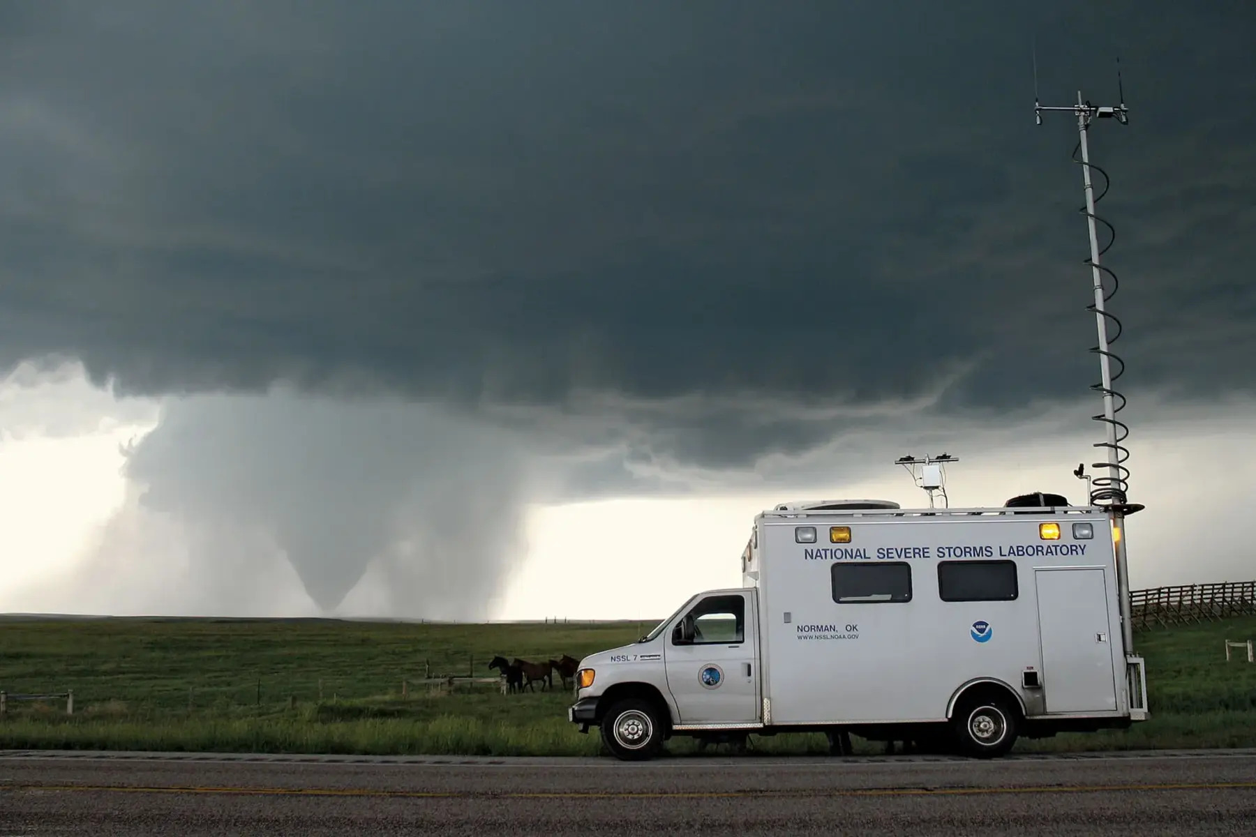
Storm Spotting and Chaser Networks
Storm spotting and chaser networks play a crucial and active role in tornado monitoring. These networks consist of trained individuals who are passionate about severe weather and actively seek out and report tornadoes and other dangerous weather phenomena. Their observations and reports supplement the data from radar systems and provide valuable ground-level information.
Storm spotters are trained volunteers who are often part of local emergency management agencies, amateur radio networks, or meteorological organizations. They are equipped with knowledge about tornado formation and identification, as well as the ability to distinguish tornadoes from other types of severe weather. Storm spotters are strategically positioned in communities across tornado-prone regions, ready to report any tornado sightings to meteorologists and emergency officials immediately.
Chaser networks consist of storm chasers, who actively pursue severe weather events, including tornadoes. These individuals may be professional meteorologists, researchers, or weather enthusiasts who travel extensively to witness and document tornadoes firsthand. They use advanced equipment such as mobile weather stations, Doppler radar units, and GPS devices to track and monitor tornado activity on the ground.
Both storm spotters and chasers provide invaluable real-time information about tornadoes as they occur. Their reports help meteorologists validate radar data and improve the accuracy of tornado warnings and forecasts. They also contribute to the scientific understanding of tornado formation and behavior, as their direct observations provide valuable insights into tornado dynamics.
Storm spotting and chaser networks have benefitted significantly from advancements in technology and the widespread availability of mobile devices and communication tools. Real-time reporting through mobile apps, social media platforms, and dedicated storm spotting networks have made it easier for storm spotters and chasers to share information with meteorologists and the public.
These networks also serve as an important link between the weather experts and the community. They not only provide early warnings but also play a critical role in educating the public about tornado safety and preparedness. By disseminating information about tornado threats and precautionary measures, storm spotters and chasers help communities become better prepared and increase their resilience to these severe weather events.
Lightning Detection Systems
Lightning detection systems are valuable tools in tornado monitoring and serve as an important component of severe weather forecasting. These systems are designed to detect and track lightning strikes, providing crucial information about thunderstorms and indicating the potential for tornado formation.
Lightning detection systems employ a network of sensors, strategically placed in various locations, to capture the electromagnetic signals produced by lightning discharges. The sensors can accurately measure the time, location, and intensity of each lightning strike. By analyzing the data from multiple sensors, meteorologists can determine the direction and speed of thunderstorm cells, helping them anticipate tornado development.
Lightning is a common occurrence in severe thunderstorms, including those with the potential for tornado formation. The intense electrical activity associated with lightning can indicate the presence of strong convective updrafts, which are essential for tornado initiation. By monitoring lightning patterns, meteorologists can identify regions of increased storm intensity and identify developing or intensifying storm cells that may produce tornadoes.
Lightning detection systems have advanced significantly in recent years, with improved technology and algorithms. Newer systems can detect not only cloud-to-ground lightning but also intracloud and cloud-to-cloud discharges. This comprehensive detection capability enhances the accuracy of thunderstorm tracking and provides additional insights into the atmospheric conditions favorable for tornadoes.
In addition to aiding in tornado prediction, lightning detection systems help in issuing timely warnings for other severe weather hazards, such as heavy rain, strong winds, and hail. This information is crucial for public safety and emergency response planning, allowing communities to take necessary precautions and mitigate potential risks.
Integration of lightning detection data with other monitoring tools, such as radar and satellite imagery, improves the overall accuracy of severe weather forecasts. Combining these datasets provides meteorologists with a more comprehensive understanding of storm dynamics, contributing to more precise tornado predictions and improved warning lead times.
Lightning detection systems not only support tornado monitoring but also contribute to the broader understanding of severe weather events. By analyzing the relationship between lightning activity and storm characteristics, scientists can gain insights into the formation and development of tornadoes, advancing our knowledge of these destructive phenomena.
Overall, lightning detection systems play a vital role in tornado monitoring, providing valuable information about thunderstorm behavior and the potential for tornado genesis. With ongoing advancements in technology, these systems continue to enhance the accuracy of severe weather forecasts and warnings, helping communities prepare and mitigate the impacts of tornadoes.
Tornado Probe Missions
Tornado probe missions involve sending specially designed instruments and equipment into tornadoes to collect valuable data and gain a better understanding of their structure and behavior. These missions provide meteorologists with critical insights into the dynamics of tornadoes and help improve tornado forecasting and warning systems.
Tornado probes are typically deployed by trained professionals, such as meteorologists or researchers, using specialized vehicles equipped with advanced weather monitoring instruments. These instruments, including anemometers, humidity sensors, and pressure gauges, are designed to withstand the extreme conditions within a tornado and provide real-time measurements of the tornado’s characteristics.
One of the primary goals of tornado probe missions is to understand the internal workings of tornadoes. By making direct measurements, scientists can gather data on wind speeds, temperature differentials, and pressure gradients within tornadoes. This information helps enhance our understanding of tornado formation and intensification, providing valuable insights into the factors influencing their development.
In addition to gathering data on tornado characteristics, probe missions also contribute to the validation of other monitoring systems, such as radar. By comparing the measurements obtained from probes with radar data, meteorologists can improve the accuracy of tornado detection and enhance forecasting models.
Tornado probe missions also have the potential to provide valuable visual documentation of tornadoes. By capturing images and videos from within the tornado, scientists can analyze the tornado’s structure, including the presence of multiple vortices, funnel shape, and any other notable features. These visuals aid in the classification and characterization of tornadoes, helping refine tornado rating scales.
While tornado probe missions offer valuable insights into tornado behavior, they also come with inherent risks. Tornadoes are highly dynamic and destructive, making it essential for researchers to exercise extreme caution and prioritize safety during these missions. Detailed planning, extensive training, and well-defined safety protocols are crucial to ensuring the safety of the probe mission participants.
The data collected from tornado probe missions contributes to ongoing research on tornadoes and helps improve tornado forecasting and warning systems. By refining our understanding of tornado dynamics and behavior, meteorologists can enhance their ability to predict tornadoes, issue timely warnings, and ultimately save lives.
Mobile Apps and Weather Websites
Mobile apps and weather websites have become essential tools for accessing up-to-date weather information, including tornado monitoring and forecasting. These platforms provide convenient access to real-time weather data, radar images, severe weather alerts, and other valuable information, empowering individuals to stay informed and prepared for tornadoes and other severe weather events.
Weather apps offer a user-friendly interface that allows users to customize their weather preferences and receive personalized alerts. These alerts can notify users about severe weather watches and warnings, including tornado warnings specific to their location. By delivering timely notifications, weather apps help users take immediate action and seek shelter when a tornado is approaching.
Additionally, weather apps and websites provide access to radar images and satellite data, allowing users to view the development and movement of storms in real-time. With the ability to zoom in and out, track storm cells, and analyze their intensity, individuals can gain a better understanding of the tornado threat in their vicinity.
Many weather apps and websites also offer advanced features such as storm tracking and prediction models. Users can track storms and tornadoes as they progress and receive forecast information on the potential path and timing of severe weather. This helps individuals plan and make informed decisions to ensure their safety.
Weather apps also facilitate communication and information sharing within communities. Users can report severe weather observations, including tornado sightings, directly through the app, contributing to the collective knowledge and awareness of dangerous weather conditions. This crowd-sourced data helps meteorologists validate and refine their tornado monitoring and forecasting efforts.
Furthermore, weather apps and websites often provide educational resources and safety tips for tornado preparedness. Users can access information on creating an emergency plan, identifying safe shelters, and understanding tornado warning systems. This empowers individuals to take proactive measures and increases their overall resilience to tornadoes.
The widespread availability and accessibility of weather apps and websites make them valuable tools for tornado monitoring and preparedness. By putting real-time weather information at users’ fingertips, these platforms contribute to improving public safety and ensuring timely response to severe weather events.
It is important to note that while weather apps and websites are valuable resources, they should not be the sole source of information during severe weather situations. Official weather alerts from meteorological authorities and local emergency management agencies should always be followed for the most accurate and up-to-date information.
Advanced Computer Models and Simulations
Advanced computer models and simulations have revolutionized tornado monitoring and forecasting by providing highly detailed and accurate predictions of tornado occurrence, movement, and intensity. These models use complex algorithms and numerical simulations to replicate the atmospheric conditions that lead to tornado formation, allowing meteorologists to study tornado dynamics and improve tornado forecasting capabilities.
Computer models utilize vast amounts of meteorological data, including atmospheric pressure, temperature, humidity, and wind patterns, to simulate the behavior of tornadoes. By incorporating various environmental factors and physical processes, these models can generate simulated tornado events, providing insight into the mechanisms behind tornado formation and evolution.
One of the key advantages of computer models is their ability to analyze and predict tornado activity in high resolution over large geographical areas. These models incorporate fine-scale details of the terrain, such as hills, mountains, and coastlines, which can influence local weather patterns and tornado formation. By capturing the intricate interactions between the atmosphere and the topography, computer models produce more accurate forecasts and improve our understanding of tornado behavior in complex geographical settings.
Furthermore, computer models complement other observational data sources, such as radar and satellite imagery. They can assimilate real-time data from these sources, combining it with their own simulations to create a more accurate representation of the current atmospheric state. This integration of data from multiple sources enhances tornado detection and allows meteorologists to issue more timely warnings.
Advancements in computing power and technology have led to the development of increasingly sophisticated tornado prediction models. These models incorporate factors such as boundary layer processes, convective instability, and wind shear, which are essential for tornado formation. By simulating these interactions, the models can provide more precise forecasts of the potential for tornado development and intensity.
Computer models also contribute to our ability to understand the impact of climate change on tornado activity. By examining data from past tornadoes and running simulations based on different climate scenarios, scientists can evaluate how changes in temperature, humidity, and atmospheric conditions under global warming may influence tornado occurrence and characteristics.
While computer models have greatly advanced our understanding of tornadoes, they are not infallible and have limitations. Factors such as uncertainties in atmospheric data, the complexity of tornado physics, and the challenges in simulating mesoscale processes can lead to uncertainties in model predictions. Continuous improvements in model resolution, data assimilation techniques, and physics parameterizations are ongoing to address these limitations and enhance tornado forecasting accuracy.