
What is a Snapchat Geotag?
A Snapchat Geotag is a location-based filter that can be applied to your snaps or stories on the Snapchat platform. Geotags allow users to customize their content by adding a specific design or logo that corresponds to a particular location or event. These filters are available for users to apply and enhance their snaps in real-time, providing an interactive and personalized experience for both creators and viewers.
Geotags can range from simple designs, such as the name of a city or landmark, to more elaborate and custom-made designs tailored to a specific business or event. These location-based filters are a fun and engaging way to showcase your whereabouts and share your experiences with friends, family, and followers.
One of the main benefits of using Snapchat Geotags is the ability to promote your brand, business, or event to a targeted audience. Companies can create custom Geotags that feature their logo or brand elements, providing users with an added layer of brand recognition and promoting their products or services. For example, a coffee shop can design a Geotag with their logo and offer it as a filter for users who are in close proximity to their location.
Furthermore, Snapchat Geotags are often used to commemorate special events or celebrations. Whether it’s a music festival, a wedding, or a birthday party, creating a custom Geotag can add a personalized touch to the occasion. Users attending the event can add the Geotag to their snaps, allowing them to share their experiences and contribute to the collective memory of the event.
To create a Snapchat Geotag, you will need to design a filter, choose a location, and submit your Geotag to Snapchat for approval. Once approved, you can use the Geotag to enhance your snaps and stories, and even track their performance through Snapchat’s analytics.
In the following sections, we will explore the step-by-step process of creating a Snapchat Geotag, from designing the filter to monitoring its performance. So, let’s dive in and get started!
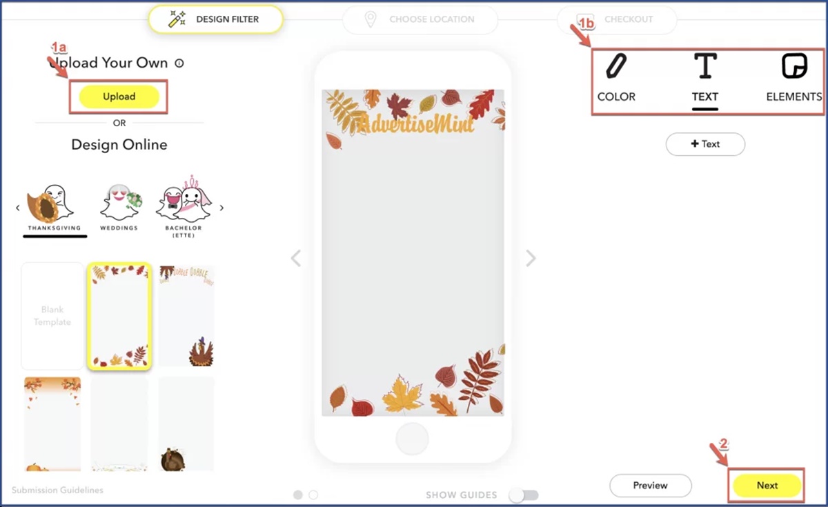
Step 1: Create a Design
The first step in creating a Snapchat Geotag is to design the filter that will be applied to your snaps or stories. This design should be visually appealing, representative of your brand or event, and appropriate for the location you choose.
When creating your design, consider the following tips:
- Keep it simple: A cluttered or complicated design may not translate well onto a small mobile screen. Opt for clear and straightforward visuals that can be easily recognized.
- Make it stand out: Your Geotag should grab users’ attention and differentiate itself from other filters. Use vibrant colors, bold typography, or unique graphics to make your design visually appealing.
- Be relevant: Consider the location or event you are targeting with your Geotag. Incorporate elements that are associated with that specific place or occasion, making it more meaningful and relatable to users.
- Ensure it meets Snapchat’s guidelines: Before finalizing your design, review Snapchat’s Geofilter Submission Guidelines to ensure that your filter adheres to their requirements. This includes avoiding logos or trademarks that you do not have permission to use.
Once you have a clear vision for your design, you can proceed to the next step of creating your Snapchat Geotag.
There are various design tools available that can assist you in creating your Geotag. Snapchat provides a specific web-based tool called “Snapchat Geofilter Studio” that allows users to design their Geotags easily. Alternatively, you can use graphic design software such as Adobe Photoshop or Canva to create your filter.
Take your time to experiment with different design ideas and make sure your Geotag accurately represents your brand or event. Remember to save the design in the appropriate file format recommended by Snapchat (e.g., PNG with a transparent background) to ensure a seamless integration into the platform.
With your design ready, you can now move on to the next step of the process: choosing a location for your Snapchat Geotag.
Step 2: Use a Design Tool
Now that you have a clear vision for your Snapchat Geotag design, it’s time to utilize a design tool to bring your ideas to life. There are several options available to help you create your Geotag, each with its own features and capabilities.
One of the most popular tools for designing Snapchat Geotags is the Snapchat Geofilter Studio. This web-based tool provides users with an intuitive and user-friendly interface to create their filters. To access the Snapchat Geofilter Studio, visit Snapchat’s website and navigate to the Geofilter section.
When using the Snapchat Geofilter Studio, you will have access to a library of design elements, such as stickers, text, and graphics, that you can use to customize your Geotag. You can also upload your own design if you prefer a more personalized touch.
If you prefer to use external design software, Adobe Photoshop is a powerful option. With its extensive set of tools and capabilities, you can create intricate designs that meet your specific requirements. However, keep in mind that Photoshop can be complex for beginners, and some basic knowledge of the software is recommended.
For those who are not familiar with graphic design software, Canva is a user-friendly and accessible option. Canva offers a wide range of pre-designed templates and customizable elements that can be used to create professional-looking Geotags with ease. Additionally, Canva provides a simple drag-and-drop interface that makes designing a breeze for beginners.
Regardless of the design tool you choose, make sure to follow Snapchat’s design guidelines. These guidelines specify the proper file formats, dimensions, file sizes, and other requirements that must be met for your Geotag to be successfully uploaded and applied to snaps and stories.
Once you have finished designing your Geotag using the tool of your choice, save it in the recommended file format (PNG with a transparent background) to maintain the integrity of your design when applied to Snapchat.
Now that your Geotag design is complete, it’s time to move on to the next step: choosing a location for your Snapchat Geotag.
Step 3: Choose a Location
Choosing the right location for your Snapchat Geotag is crucial to ensure maximum visibility and engagement with your target audience. The location you select should be relevant to your brand, event, or target audience to make the Geotag more meaningful and appealing.
Here are some considerations when choosing a location:
- Geographical relevance: Select a location that aligns with the purpose or theme of your Geotag. For instance, if you’re promoting a local business or event, choose a location near the venue to target users in that area.
- High foot traffic: Opt for locations where there is a high concentration of Snapchat users. This could include popular landmarks, tourist attractions, shopping centers, universities, or event venues.
- Target audience: Consider the demographics and interests of your target audience. Choose a location that is likely to attract your desired audience, whether it’s based on age, interests, or other factors.
- Exclusive or limited access: If you’re hosting a private event or offering a special promotion, selecting a location that requires an invitation or limited access can create a sense of exclusivity and urgency for Snapchat users.
When choosing a location, it’s important to keep in mind that Snapchat has certain guidelines and restrictions for Geotags. Make sure to review and comply with these guidelines to prevent any issues during the submission process.
Once you have identified the ideal location for your Geotag, you can proceed to the next step: setting up a business account on Snapchat.
Step 4: Set Up a Business Account
In order to create and submit a Snapchat Geotag, you will need to have a business account on Snapchat. Setting up a business account is easy and provides you with access to additional features and analytics to track the performance of your Geotag.
Here’s how to set up a business account on Snapchat:
- Create an account: Visit Snapchat’s website and click on “Create an Account.” Fill in your business name, email address, and password to register.
- Verify your account: Snapchat will send a verification email to the email address you provided during registration. Click on the verification link in the email to verify your account.
- Set up your business profile: Once your account is verified, you can proceed to set up your business profile. Provide relevant information such as your business name, category, and contact details. This profile will help users identify your business and find your Geotag.
- Link your Geotag to your business profile: To associate your Geotag with your business profile, make sure to select the appropriate business category during the setup process. This will ensure that your Geotag appears when users search for filters related to your business or industry.
- Add payment information: Snapchat Geotags are not free, and you will need to provide payment information to cover the cost of running your Geotag. Snapchat offers different pricing models based on factors such as location size and duration of use. Review the pricing options and select the one that best suits your budget.
Once you have set up your business account and completed the required steps, you are ready to move on to the next step: submitting your Geotag to Snapchat for review and approval.
Step 5: Submit Your Geotag to Snapchat
After designing your Snapchat Geotag, choosing a location, and setting up your business account, it’s time to submit your Geotag to Snapchat for review and approval. Follow these steps to ensure a smooth submission process:
- Access the Geofilter submission page: Visit Snapchat’s website and navigate to the Geofilter submission page. You can find this under the Business section of the website.
- Upload your Geotag design: Click on the option to “Upload a Geotag” and select the file of your Geotag design from your computer. Make sure the file meets Snapchat’s guidelines regarding format, size, and dimensions.
- Select the location: Indicate the location where you want your Geotag to be available by dragging and resizing the provided map. Ensure that your Geotag covers the desired area without extending beyond the boundaries.
- Set the duration: Choose the duration for which you want your Geotag to be active. Snapchat offers options ranging from a few hours to several weeks. Consider the duration of your event or promotion when making this selection.
- Review and submit: Double-check all the details you have entered, including the location, duration, and design. Once you are satisfied, click on the submit button to send your Geotag for review.
It’s important to note that Snapchat has review guidelines in place to ensure that submitted Geotags adhere to their policies and community standards. The review process typically takes a few business days, during which Snapchat will evaluate your Geotag for compliance and appropriateness.
If your Geotag is approved, you will receive a notification, and it will become active on the specified date and time. If it is rejected, Snapchat will provide you with feedback on why it was not approved. You can make the necessary adjustments and resubmit your Geotag for review.
Once your Geotag is live, users in the specified location will be able to apply it to their snaps or stories, creating an interactive and engaging experience with your brand or event.
In the next step, we will discuss the process of monitoring the performance of your Snapchat Geotag and making necessary updates.
Step 6: Wait for Approval
After submitting your Snapchat Geotag for review, the next step is to patiently wait for approval from the Snapchat team. The review process typically takes a few business days, during which Snapchat will carefully evaluate your Geotag for compliance with its guidelines and policies.
While waiting for approval, here are a few things you can do:
- Be patient: The review process may take some time, so it’s important to be patient and avoid submitting multiple Geotags for the same location simultaneously. Each submission will be reviewed individually, and submitting multiple designs may slow down the overall process.
- Double-check your submission: Take the time to review your Geotag design, location, duration, and any other details you provided during the submission process. Make sure everything is accurate and aligns with your goals and objectives.
- Track your email notifications: Snapchat will notify you via email regarding the status of your Geotag submission. Keep an eye on your email inbox for any updates or notifications from Snapchat.
- Make adjustments if necessary: If your Geotag is rejected, Snapchat will provide you with feedback and guidelines for improvement. Take this opportunity to make the necessary adjustments and modifications before resubmitting your Geotag for review.
During the waiting period, it’s essential to remain proactive and prepared for any changes that may be required. Keep an open line of communication with your team, designers, or any other stakeholders involved in the Geotag creation process.
Remember, the Snapchat team reviews Geotags to ensure they meet the platform’s guidelines and provide an engaging and appropriate experience for users. By following the guidelines and best practices discussed earlier, you increase the chances of a successful approval and activation of your Geotag.
Once your Geotag is approved, it will become active at the designated time and users in the specified location will be able to use it on their snaps or stories, enhancing their content and promoting your brand or event in an interactive way.
In the next step, we will explore how to monitor the performance of your Snapchat Geotag and make necessary updates as needed.
Step 7: Monitor the Performance of Your Geotag
Once your Snapchat Geotag is approved and active, it’s important to monitor its performance to gain insights and make any necessary updates. Regularly analyzing the data and metrics associated with your Geotag will help you assess its effectiveness and make informed decisions to optimize its impact.
Here’s how you can monitor the performance of your Geotag:
- Use Snapchat’s analytics: Snapchat provides analytics tools that allow you to track the performance of your Geotag. Log into your business account and access the analytics dashboard to view metrics such as usage, reach, and engagement. Analyze these metrics to understand how users are interacting with your Geotag and identify areas for improvement.
- Track social media mentions: Keep an eye on social media platforms to see if users are mentioning or sharing their snaps with your Geotag. Monitor hashtags or keywords related to your Geotag to gauge its visibility and gauge public sentiment.
- Engage with users: Interact with users who engage with your Geotag by liking or replying to their snaps or stories. Show appreciation for their support and encourage them to continue using your Geotag, fostering a sense of community and loyalty.
- Solicit feedback: Reach out to users who have used your Geotag and ask for feedback on their experience. This can provide valuable insights on what users like or dislike about your Geotag and help you make informed adjustments to enhance its appeal.
- Experiment with updates: Based on the performance data and user feedback, consider making updates or modifications to your Geotag design or location. This could involve refreshing the design periodically, targeting new locations, or aligning the Geotag with seasonal events or promotions.
By monitoring the performance of your Snapchat Geotag, you can gather valuable insights and continuously refine your strategy to maximize its impact. Remember to analyze the data regularly and use it to inform your decision-making process.
As part of the monitoring process, it’s essential to keep an eye on any changes or updates introduced by Snapchat that may affect the functionality or visibility of Geotags. Stay informed about any platform changes to ensure your Geotag continues to align with Snapchat’s guidelines and provides the best user experience.
With the ability to track and optimize your Geotag’s performance, you can ensure that it remains relevant and engaging, enhancing your brand’s presence and connecting with Snapchat users in a meaningful way.
Finally, let’s explore how to update and modify your Geotag to keep it fresh and relevant.
Step 8: Update and Modify Your Geotag
Keeping your Snapchat Geotag fresh and relevant is essential for maintaining user engagement and maximizing its impact. As trends change and your brand evolves, updating and modifying your Geotag can help you stay connected with your target audience. Here’s how you can update and modify your Geotag:
- Regularly assess performance: Continuously monitor the performance metrics of your Geotag, including usage, reach, and engagement. Identify any areas where your Geotag may be underperforming or opportunities for improvement.
- Collect user feedback: Engage with users who have used your Geotag and gather feedback on their experience. Pay attention to their suggestions, concerns, and preferences. This will help you understand how to better align your Geotag with their expectations.
- Refresh the design: Consider updating the design of your Geotag periodically to keep it visually appealing and on-trend. This can include incorporating seasonal elements, leveraging new graphic styles, or introducing a refreshed logo.
- Experiment with different locations: Explore new locations for your Geotag to reach different audiences or target specific events or occasions. This can help expand your Geotag’s visibility and attract a broader user base.
- Collaborate with influencers or partners: Collaborating with influencers or business partners can bring fresh perspectives and new audiences to your Geotag. Consider partnering with relevant influencers or businesses to boost the visibility and engagement of your Geotag.
- Align with current trends: Stay up to date with current trends and themes that resonate with your target audience. Incorporating popular hashtags, memes, or cultural events can make your Geotag more relatable and shareable.
- Promote your Geotag: Actively promote your Geotag through various marketing channels, including social media, email campaigns, and physical signage. Encourage users to use your Geotag and share their experiences with their followers.
Updating and modifying your Geotag demonstrates your brand’s commitment to staying relevant and engaging with Snapchat users. By paying attention to performance metrics, user feedback, and market trends, you can make informed decisions on how to improve and optimize your Geotag’s impact.
Remember to review and comply with Snapchat’s guidelines when making updates or modifications to your Geotag. This ensures that your Geotag continues to adhere to the platform’s requirements and provides a seamless user experience.
By regularly updating and modifying your Geotag, you can maintain user interest, increase brand visibility, and foster strong connections with your target audience on Snapchat.