
Why You Need Coordinates from Google Maps
Coordinates are an essential component of location data that provide precise geographic information. Obtaining coordinates from Google Maps can be beneficial in several situations. Whether you’re planning a trip, navigating unfamiliar terrain, or conducting research, having accurate coordinates can significantly enhance your experience.
One of the primary reasons you might need coordinates from Google Maps is for navigation purposes. By having the precise latitude and longitude of a location, you can input those coordinates into a GPS device or mobile app to get accurate directions. This is especially useful when exploring remote areas or off-road trails where traditional street addresses may not be available.
Moreover, coordinates can provide valuable information for outdoor enthusiasts and adventure seekers. Hikers, climbers, and backpackers can use coordinates to pinpoint trailheads, campsites, and other points of interest along their journey. This ensures that they stay on the right path, stay safe, and have a more enjoyable outdoor experience.
Researchers and academics also frequently rely on coordinates from Google Maps. Whether you’re studying geography, environmental science, or urban planning, having precise coordinates allows for accurate data collection and analysis. Researchers can mark specific locations, observe patterns, and compare data from different places using these coordinates.
Additionally, if you’re a business owner or marketer, coordinates can be invaluable in promoting your physical location. By including coordinates in your website, social media profiles, or online listings, potential customers can find your business more easily. Providing accurate coordinates also helps customers navigate to your location without any confusion.
Finally, coordinates from Google Maps can be crucial in emergency situations. If you find yourself in an unfamiliar area and need to provide your location to emergency services, having coordinates can ensure that help reaches you quickly and accurately.
Methods to Get Coordinates from Google Maps
Google Maps offers various methods to obtain coordinates, whether you’re using the navigation app on your mobile device or accessing the Google Maps website on your computer. Here are some popular methods:
1. Using the Navigation App on Your Mobile Device: If you’re on the go, the Google Maps app on your smartphone can provide you with real-time coordinates. Simply open the app, enter the desired location in the search bar, and tap and hold on the map to drop a pin. The coordinates will then be displayed at the bottom of the screen.
2. Obtaining Coordinates on Google Maps Website: To use this method, open the Google Maps website on your computer. Search for the desired location in the search bar, and right-click on the map where you want to obtain the coordinates. A small box will appear with the coordinates displayed.
3. Getting Coordinates from the Google Maps Mobile App: Similar to the website method, open the Google Maps app on your smartphone. Search for the location, tap and hold on the map, and a red pin will drop. The coordinates will be shown at the bottom of the screen.
4. Extracting Coordinates from a Google Maps URL: If you have a link to a specific location on Google Maps, you can extract the coordinates from the URL itself. Look for the section in the URL that starts with “@,” followed by the latitude and longitude numbers. These numbers represent the coordinates.
5. Using the “What’s Here” Feature to Get Coordinates: This method allows you to find coordinates for a specific point on the map. Right-click on the location you’re interested in, and select “What’s here?” A small box will appear with the coordinates displayed.
6. Using the “Measure Distance” Feature to Obtain Coordinates: If you need coordinates for a specific distance along a route or between two points, you can use the “Measure Distance” feature on Google Maps. Click the ruler icon in the menu bar, and click on the map to create points. The coordinates will be displayed as you create the points.
7. Using the “Find My Location” Feature to Get Coordinates: If you’re unsure of your current coordinates, you can use the “Find My Location” feature on the Google Maps app. This feature uses GPS to pinpoint your location and displays your exact coordinates.
8. Using Third-Party Websites or Apps to Extract Coordinates from Google Maps: There are also third-party websites and apps that offer the option to extract coordinates directly from Google Maps. These tools may provide additional features and flexibility for extracting and manipulating coordinate data.
With these methods at your disposal, you can easily obtain the coordinates you need from Google Maps for various purposes.
Using the Navigation App on Your Mobile Device
When you’re on the go and need to quickly obtain coordinates from Google Maps, using the navigation app on your mobile device is a convenient option. Here’s how you can do it:
1. Open the Google Maps app on your smartphone. If you don’t have it installed, you can download it from the App Store (iOS) or Play Store (Android).
2. Once the app is open, use the search bar at the top to enter the desired location for which you need the coordinates. It can be an address, landmark, or any specific point on the map.
3. After entering the location, Google Maps will display the search results. Tap on the result that corresponds to the correct location you want to obtain the coordinates for.
4. Once you’ve selected the location, Google Maps will zoom in to show you the map. To drop a pin and get the coordinates, simply tap and hold on the map at the exact point where you want the coordinates. You will see a red pin appear at that location.
5. At the bottom of the screen, you will find a small information box with details about the location. Scroll down within the information box to find the coordinates. The latitude and longitude values will be displayed in decimal format.
6. Take note of the coordinates for future reference. You can either write them down or take a screenshot of the information box.
7. If needed, you can also use the share button within the information box to send the coordinates to someone via message, email, or any other sharing option available on your device.
By using the navigation app on your mobile device, you can quickly and easily obtain coordinates from Google Maps on the go. This method is especially useful when you’re in a new location or navigating unfamiliar surroundings and need accurate coordinates for directions or other purposes.
Obtaining Coordinates on Google Maps Website
If you’re accessing Google Maps on your computer and need to obtain coordinates for a specific location, you can easily do so using the Google Maps website. Follow these steps:
1. Open a web browser and go to Google Maps.
2. In the search bar at the top left of the page, enter the location for which you want to obtain the coordinates. You can enter an address, landmark, or any specific point on the map.
3. After entering the location, Google Maps will display the search results. Click on the result that corresponds to the correct location you want to obtain the coordinates for.
4. Once the location is selected, Google Maps will zoom in to show the map. Right-click on the exact point on the map where you want to obtain the coordinates.
5. A small box will appear at the bottom of the screen with information about the location. Within this box, you will find the coordinates displayed under the latitude and longitude labels. The numbers will be in decimal format.
6. Take note of the coordinates for future reference. You can either write them down or copy them to a text document or note-taking app.
7. If needed, you can also click on the “Share” button within the information box to share the coordinates via email, message, or any other sharing option available on your computer.
By using the Google Maps website on your computer, you can quickly obtain coordinates for any desired location. This method is particularly useful when you’re planning a trip, conducting research, or need accurate coordinates for mapping or navigation purposes.
Getting Coordinates from the Google Maps Mobile App
If you’re using the Google Maps mobile app on your smartphone, obtaining coordinates for a specific location is a simple process. Follow these steps:
1. Open the Google Maps app on your smartphone. If you don’t have it installed, you can download it from the App Store (iOS) or Play Store (Android).
2. Once the app is open, use the search bar at the top to enter the location for which you need the coordinates. You can enter an address, landmark, or any specific point on the map.
3. After entering the location, Google Maps will display the search results. Tap on the result that corresponds to the correct location you want to obtain the coordinates for.
4. Once you’ve selected the location, Google Maps will zoom in to show you the map. To drop a pin and get the coordinates, simply tap and hold on the map at the exact point where you want the coordinates. You will see a red pin appear at that location.
5. At the bottom of the screen, you will find a small information box with details about the location, including the coordinates. Scroll down within the information box to find the latitude and longitude values in decimal format.
6. Take note of the coordinates for future reference. You can either write them down or save a screenshot of the information box.
7. If needed, you can also tap the share button within the information box to send the coordinates to someone via message, email, or any other sharing option available on your device.
By using the Google Maps mobile app, you can quickly and easily obtain coordinates for any desired location. This method is especially useful when you’re on the go or need to navigate to a specific point using your smartphone.
Extracting Coordinates from a Google Maps URL
If you have a Google Maps URL for a specific location, extracting coordinates from it can be a quick way to obtain the latitude and longitude values. Here’s how you can extract coordinates from a Google Maps URL:
1. Copy the Google Maps URL that contains the location you’re interested in.
2. Paste the URL into a text editor or directly into the address bar of your web browser.
3. Look for a section in the URL that starts with “@” followed by a set of numbers. These numbers represent the latitude and longitude values of the location.
4. The latitude is the number before the comma (“,”) in the URL, and the longitude is the number after the comma. For example, if the URL contains “@40.7128,-74.0060”, the latitude is 40.7128 and the longitude is -74.0060.
5. Take note of the extracted latitude and longitude values for future reference.
Alternatively, you can use an online URL decoder or coordinate extractor tool to automatically extract the coordinates from the Google Maps URL. Simply copy and paste the URL into the tool, and it will display the latitude and longitude values for you.
Extracting coordinates from a Google Maps URL is a handy method when you already have the URL and just need to quickly obtain the latitude and longitude values without manually searching for the location on Google Maps.
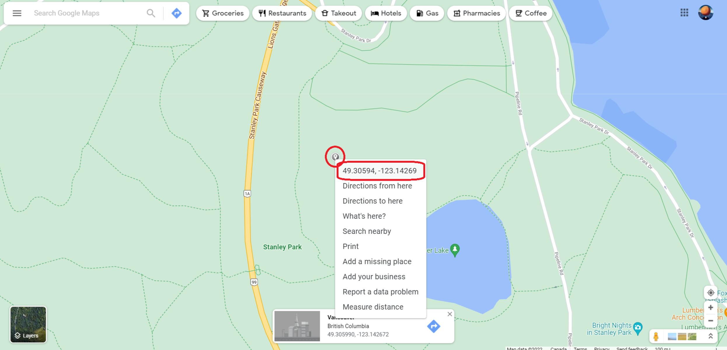
Using the “What’s Here” Feature to Get Coordinates
If you want to get the coordinates for a specific point on the map, you can use the “What’s Here” feature on Google Maps. This feature allows you to pinpoint a location and retrieve its precise latitude and longitude values. Here’s how you can use the “What’s Here” feature:
1. Open the Google Maps website on your computer or the Google Maps mobile app on your smartphone.
2. Search for the general area or location where the point of interest is located.
3. Zoom in or scroll around the map until the desired point is within view.
4. Right-click on the exact spot on the map where you want to obtain the coordinates for.
5. From the right-click menu that appears, select the “What’s Here” option.
6. A small box or bubble will pop up on the map, displaying the coordinates for the selected point. The latitude and longitude values will typically be shown in decimal format.
7. Take note of the coordinates for future reference. You can either write them down or copy the numbers to a text document or note-taking app.
In addition, some versions of Google Maps may display the coordinates directly in the search bar at the top of the page after using the “What’s Here” feature. Check the search bar after performing the steps above to see if the coordinates are already provided there.
The “What’s Here” feature is a useful tool for pinpointing specific locations and obtaining their coordinates with ease. Whether you need coordinates for a specific point of interest or for research purposes, this feature can help you find the precise latitude and longitude values you need.
Using the Measure Distance Feature to Obtain Coordinates
If you need to obtain coordinates for a specific distance along a route or between two points, you can utilize the “Measure Distance” feature on Google Maps. This feature allows you to measure distances on the map and obtain the coordinates along the measured path. Here’s how you can use the Measure Distance feature:
1. Open the Google Maps website on your computer or the Google Maps mobile app on your smartphone.
2. Search for the general area or location where you want to measure the distance.
3. Pinpoint the starting point for your measurement by clicking or tapping on the map.
4. Right-click (on a computer) or long-press (on a mobile device) the starting point, and select the “Measure Distance” option.
5. A white dot will appear at the starting point, and a black line will follow your cursor as you move it across the map.
6. Click or tap at various points along the path to measure the distance. Each click or tap will add a point on the map and update the distance measurement accordingly.
7. Once you have measured the desired distance or have reached the second point of interest, right-click (on a computer) or long-press (on a mobile device) anywhere on the map to finish the measurement.
8. The total distance of the measured path will be displayed on the map. Additionally, you can click or tap on any of the points along the path to see the coordinates for that specific point.
9. Take note of the coordinates for the desired points along the measured path. You can either write them down or save a screenshot for future reference.
The Measure Distance feature on Google Maps is a helpful tool for obtaining coordinates along a specific distance. Whether you need coordinates for a point of interest or for navigation purposes, this feature allows you to measure distances and pinpoint the corresponding latitude and longitude values along the measured path.
Using the Find My Location Feature to Get Coordinates
If you’re unsure of your current coordinates and need to quickly determine your location, you can utilize the “Find My Location” feature on Google Maps. This feature uses GPS technology to pinpoint your exact location and display the corresponding coordinates. Here’s how you can use the Find My Location feature:
1. Open the Google Maps mobile app on your smartphone. If you don’t have it installed, you can download it from the App Store (iOS) or Play Store (Android).
2. Once the app is open, tap on the blue dot icon indicating your current location. This will activate the Find My Location feature.
3. Google Maps will use GPS technology to determine your precise location. Once your location is identified, a blue dot will appear on the map representing your current position.
4. Tap on the blue dot to display a small pop-up window with information about your location, including the coordinates. The latitude and longitude values will typically be shown in decimal format.
5. Take note of the coordinates for future reference. You can either write them down or save a screenshot of the pop-up window.
The Find My Location feature is a convenient way to quickly obtain your current coordinates when you’re on the move or unfamiliar with your exact location. Whether you’re planning a trip, sharing your coordinates with others, or using it for personal reference, this feature on Google Maps allows you to easily access your latitude and longitude values with just a few taps on your smartphone.
Using Third-Party Websites or Apps to Extract Coordinates from Google Maps
In addition to the built-in features of Google Maps, there are also third-party websites and apps available that offer tools to extract coordinates directly from Google Maps. These platforms can provide additional features and flexibility for extracting and manipulating coordinate data. Here’s how you can use these third-party resources:
1. Search for a reliable third-party website or app that offers coordinate extraction tools. Some popular options include Coordinate Extractor, GPS Coordinates, and LatLong.net, among others.
2. Open the website or app and navigate to the coordinate extraction tool.
3. Enter the specific location or paste the Google Maps URL into the provided field on the website or app.
4. Click on the “Extract” or “Get Coordinates” button to initiate the extraction process.
5. The website or app will process the input and retrieve the coordinates associated with the location or the provided URL. The latitude and longitude values will be displayed on the screen.
6. Take note of the extracted coordinates for future reference. You can either write them down or copy them to a text document or note-taking app.
7. Some third-party websites or apps may also offer additional features, such as the ability to convert coordinate formats or perform calculations based on the extracted coordinates.
Using third-party websites or apps to extract coordinates from Google Maps can be beneficial if you require more advanced functionality or if you prefer a different interface for working with coordinate data. However, it is important to choose reputable sources to ensure the accuracy and safety of your data.
Overall, these third-party resources can provide an alternative method for extracting coordinates from Google Maps, offering additional tools and flexibility for working with geographic data.