
The Beginnings of Ocean Exploration
From the earliest civilizations, humans have been captivated by the vastness and mystery of the oceans. The curiosity to understand what lies beneath the surface of the water has fueled the beginnings of ocean exploration.
One of the earliest recorded instances of ocean exploration dates back to the Phoenicians, who were renowned seafarers in the Ancient Mediterranean. They ventured beyond the coastal waters and navigated to distant lands, trading goods and discovering new territories.
During the Age of Discovery, European explorers such as Christopher Columbus and Ferdinand Magellan set sail in search of new sea routes to expand trade and conquer new lands. These expeditions not only transformed world maps but propelled the exploration of oceans on a global scale.
However, it was not until the mid-19th century that ocean exploration took a significant leap forward with the launch of the HMS Challenger expedition. This scientific voyage, which lasted from 1872 to 1876, marked the birth of modern oceanography and laid the foundation for our understanding of the world’s oceans.
The Challenger expedition was the first to systematically collect data on oceanographic measurements, including water temperature, salinity, and depth. It also discovered thousands of new marine species and conducted extensive mapping of the ocean floor. The wealth of knowledge gained from this expedition sparked a newfound interest in exploring the vast oceans.
As technology advanced, so did our ability to explore the oceans. Sonar, which uses sound waves to map the ocean floor, became a crucial tool in understanding underwater topography. This development revolutionized our understanding of ocean basins and led to the discovery of diverse ecosystems, such as hydrothermal vents and deep-sea trenches.
Additionally, the invention of deep-sea submersibles and diving vehicles allowed humans to descend to great depths and observe marine life firsthand. These vessels, equipped with advanced imaging systems, enabled researchers to study underwater habitats, gather samples, and capture stunning footage of previously unexplored regions.
In recent decades, remote sensing technology and satellites have played a pivotal role in ocean exploration. Satellites can collect valuable data on sea surface temperatures, ocean currents, and even monitor the movement of marine animals. This information is crucial for understanding climate patterns, forecasting weather events, and managing marine ecosystems.
Furthermore, underwater robotics and autonomous vehicles have revolutionized the way we explore the oceans. These unmanned devices can dive to extreme depths, withstand harsh conditions, and gather data in real-time. They have proven invaluable in conducting research in remote and hazardous areas, contributing to significant discoveries in marine biology, geology, and oceanography.
The beginnings of ocean exploration have not only expanded our scientific knowledge but have also had a profound influence on technological advancements. The development of specialized equipment, data collection systems, and communication technologies has paved the way for groundbreaking discoveries and innovation in various industries.
Overall, from ancient seafarers to modern-day researchers, the drive to explore the oceans has pushed the boundaries of human knowledge and transformed our understanding of the world beneath the waves.
Early Discoveries and the Age of Discovery
The Age of Discovery, spanning from the 15th to the 17th century, marked a significant period in history when European explorers ventured into uncharted waters, uncovering new lands and making groundbreaking discoveries. These early maritime expeditions not only expanded geographical knowledge but also laid the foundation for future ocean exploration.
One of the notable figures of this era is Christopher Columbus, whose historic voyage in 1492 led to the discovery of the Americas. Columbus, a skilled navigator, set sail in search of a western route to Asia. Although he did not reach his intended destination, his encounters with the Caribbean islands opened up a new chapter in oceanic exploration.
Another prominent explorer of the Age of Discovery was Ferdinand Magellan. In 1519, Magellan embarked on an epoch-making circumnavigation of the globe, becoming the first expedition to achieve this feat. This expedition not only demonstrated the earth’s spherical shape but also revealed the vastness of the world’s oceans.
During these journeys, explorers made significant discoveries about the natural world. They encountered unfamiliar flora and fauna, such as tropical plants, exotic birds, and marine creatures previously unknown to Europeans. These observations sparked curiosity and furthered the understanding of the diversity of life on Earth.
Furthermore, these expeditions had a profound impact on navigation and cartography. The need for accurate maps and navigational tools became imperative for safe travels and the establishment of trade routes. As a result, advancements in compasses, astrolabes, and navigational charts were made, paving the way for more precise seafaring.
The Age of Discovery culminated in the mapping and exploration of vast stretches of the world’s oceans. Explorers like James Cook, Vasco da Gama, and Henry Hudson charted new routes, mapped coastlines, and navigated treacherous waters. These explorations not only expanded maritime knowledge but also led to the establishment of colonial settlements and trade networks around the world.
Through these early discoveries, scholars and naturalists gained a broader understanding of the world’s oceans and the interconnectedness of different regions. They documented variations in marine life, identified currents, and studied ocean circulation patterns. These findings laid the groundwork for future scientific expeditions and informed the development of oceanography as a scientific discipline.
The early discoveries and the Age of Discovery set the stage for future generations of explorers and scientists to delve deeper into the mysteries of the oceans. The courage, curiosity, and ingenuity of these pioneers continue to inspire modern-day oceanographers, shaping our understanding of the oceans and their vital role in the Earth’s ecosystems.
The Challenger Expedition and the Birth of Oceanography
In the mid-19th century, a remarkable scientific expedition known as the HMS Challenger set sail, embarking on a four-year voyage that would forever shape the field of oceanography. The Challenger expedition, which took place from 1872 to 1876, laid the foundation for our understanding of the world’s oceans and marked the birth of modern oceanographic research.
Under the leadership of Sir Charles Wyville Thomson, the HMS Challenger carried a team of scientists and researchers from various disciplines. Their mission was to investigate the depths of the oceans, collect data, and conduct extensive scientific observations.
The Challenger expedition was a groundbreaking endeavor because it was the first scientific voyage specifically dedicated to studying the world’s oceans in a systematic and comprehensive manner. Previous explorations had gathered limited data, but the Challenger expedition set out with a mission to thoroughly document the physical, chemical, and biological characteristics of the marine environment.
During the expedition, the scientists collected samples of water, sediment, and marine life from various depths and locations. They measured temperature, salinity, and pressure, providing invaluable data on oceanic conditions. Additionally, they carried out extensive dredging and trawling operations that revealed a plethora of new marine species, expanding our understanding of marine biodiversity.
One of the most significant achievements of the Challenger expedition was its contribution to ocean floor mapping. The expedition conducted detailed surveys and used newly developed sounding equipment to measure the depth of the ocean at different locations. These measurements were used to create the first global bathymetric maps, revealing the vast array of underwater features such as seamounts, trenches, and ridges.
The data and specimens collected by the Challenger expedition formed the basis for numerous scientific publications and laid the groundwork for the field of oceanography. Scientists were able to study the physical, chemical, and biological properties of the oceans, advancing our understanding of marine ecosystems, ocean currents, and the influence of the oceans on climate.
The knowledge acquired during the Challenger expedition sparked a newfound interest in ocean exploration and research. It led to the establishment of dedicated oceanographic institutions and the development of new research vessels and equipment to further study the oceans.
Today, the legacy of the Challenger expedition lives on, with subsequent oceanographic expeditions building upon the knowledge and methodologies developed during this groundbreaking voyage. The insights gained from the Challenger expedition continue to shape our understanding of the world’s oceans and their invaluable role in maintaining the health and equilibrium of the planet.
The Use of Sonar and Mapping the Ocean Floor
The exploration and mapping of the ocean floor have been revolutionized by the development and application of sonar technology. Sonar, short for Sound Navigation and Ranging, is a technique that uses sound waves to map the underwater topography and gather valuable information about the ocean floor.
Sonar works by emitting sound pulses into the water and measuring the time it takes for the sound waves to bounce back after hitting an object or the ocean floor. By analyzing the return signals, scientists can determine the depth, shape, and composition of the seafloor with remarkable accuracy.
The application of sonar in oceanography began in the early 20th century. The first significant advancement came with the invention of the echo sounder by Norwegian scientist Colin Archer. This device emitted sound waves and measured the time it took for the echoes to return, providing information about the depth of the water beneath the ship.
As technology progressed, so did the capabilities of sonar systems. Multibeam sonar, for example, became widely used for mapping larger areas of the ocean floor with high resolution. This type of sonar uses multiple beams of sound waves to scan the seafloor simultaneously, providing detailed bathymetric data and creating three-dimensional maps of the underwater landscape.
The mapping of the ocean floor using sonar has led to the discovery of various undersea features and geological formations. Volcanic seamounts, mid-ocean ridges, and deep-sea trenches are just a few examples of the fascinating structures observed through sonar mapping. These discoveries have greatly contributed to our understanding of plate tectonics, seafloor spreading, and the formation of Earth’s crust.
Sonar technology has also been instrumental in locating and exploring underwater cultural heritage sites, such as shipwrecks and ancient cities. By using side-scan sonar, which provides detailed imagery of the seafloor, researchers have identified and studied archaeological sites beneath the ocean’s surface, shedding light on human history and ancient civilizations.
The data collected through sonar mapping has not only contributed to scientific knowledge but has also been crucial for various practical applications. It is instrumental in the planning and installation of undersea cables, pipelines, and offshore infrastructure. Additionally, it is essential for navigational purposes, creating accurate nautical charts and ensuring safe passage for vessels.
Furthermore, sonar mapping plays a vital role in the assessment and management of marine habitats and resources. It helps identify critical habitats for marine species, locate potential areas for fishing and aquaculture, and monitor the impact of human activities on the underwater environment.
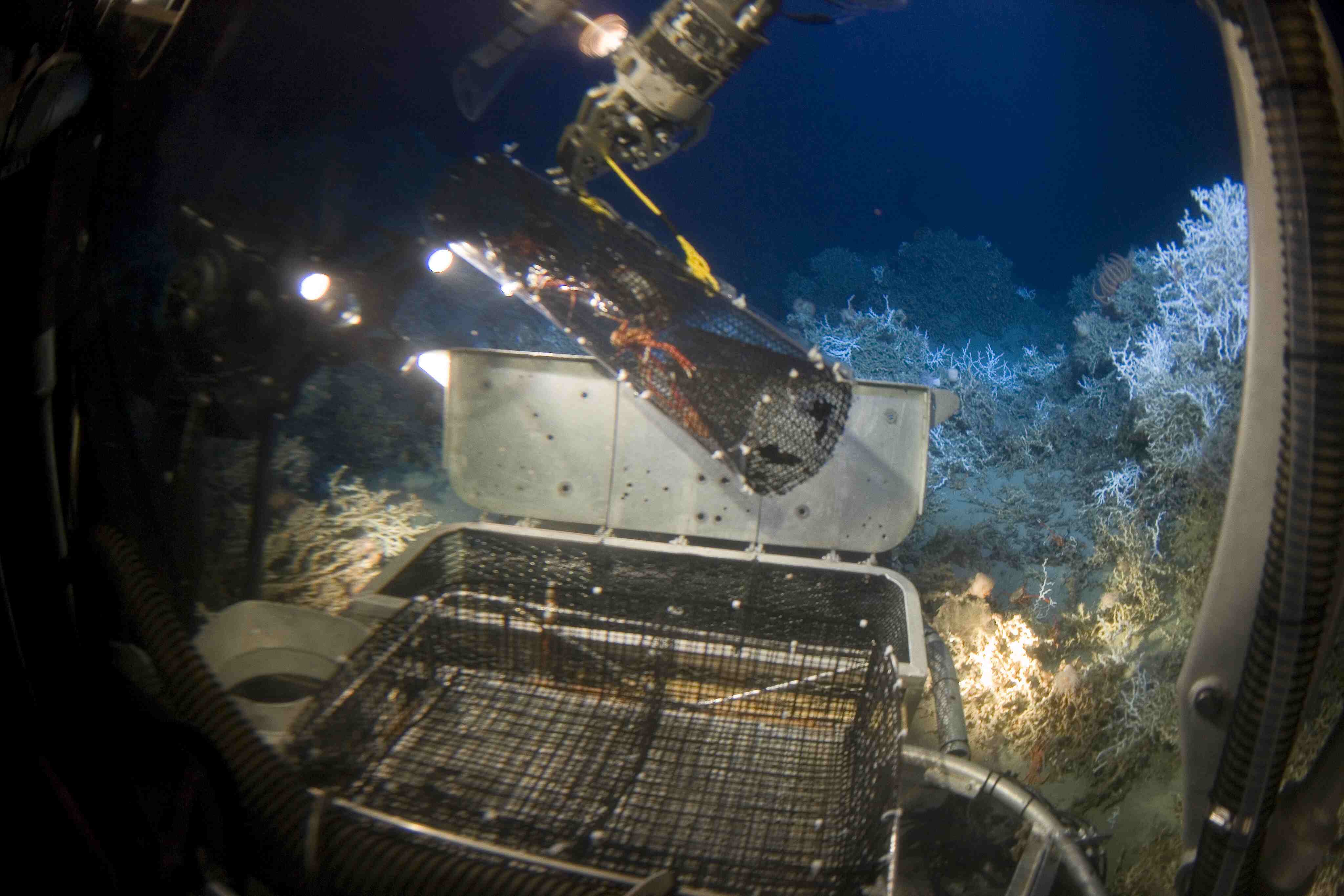
Deep-Sea Submersibles and Diving Vehicles
Deep-sea submersibles and diving vehicles have opened up a world of exploration and discovery in the deepest reaches of our oceans. These sophisticated vehicles enable scientists and researchers to descend to great depths and explore the mysteries of the underwater world in ways never before possible.
One of the most iconic deep-sea submersibles is the Alvin. First commissioned in 1964, Alvin has been pivotal in advancing our understanding of the deep ocean. With its ability to withstand extreme pressures, Alvin has carried scientists to depths of up to 4,500 meters, providing valuable insights into deep-sea ecosystems, hydrothermal vents, and underwater volcanoes.
Another notable submersible is the Deepsea Challenger, a vehicle designed by James Cameron, the renowned filmmaker and ocean explorer. In 2012, Cameron piloted the Deepsea Challenger to the bottom of the Mariana Trench, reaching a record-breaking depth of 10,908 meters. This historic dive opened up new opportunities for exploration and shed light on the previously unexplored depths of the ocean.
These submersibles are equipped with state-of-the-art technology, including high-definition cameras, sampling devices, and robotic arms, enabling scientists to collect samples, capture images, and study marine life in their natural habitats. The data and observations gathered by these vehicles have provided invaluable insights into the biodiversity and adaptations of organisms thriving in extreme conditions.
In recent years, remotely operated vehicles (ROVs) have also revolutionized deep-sea exploration. These unmanned, remotely controlled vehicles are equipped with cameras, lights, and scientific instruments that allow researchers to explore underwater environments in real-time. ROVs like the Nereus and Jason have been invaluable in studying hydrothermal vents, deep-sea coral reefs, and underwater geological formations.
Deep-sea submersibles and diving vehicles have not only facilitated scientific research but have also played a key role in underwater archaeology. They have allowed researchers to investigate and document historic shipwrecks, submerged ancient cities, and archaeological sites that offer insight into our cultural heritage.
The use of deep-sea submersibles and diving vehicles has faced many challenges, including the harsh conditions and extreme pressures that exist at great depths. However, continuous advancements in engineering and technology have enhanced the performance, durability, and safety of these vehicles, enabling deeper and longer dives.
Through the exploration conducted by deep-sea submersibles and diving vehicles, we have gained a deeper understanding of the complex and diverse ecosystems that exist in the depths of our oceans. The discoveries made by these vehicles have expanded our knowledge of the deep-sea environment, its geological features, and the adaptations of the organisms that call it home.
Remote Sensing and the Role of Satellites
In the field of oceanography, remote sensing has become a crucial tool for gathering valuable data about the vast expanses of our oceans. Remote sensing involves the use of satellites and other sensors to collect information about the Earth’s surface and atmosphere from a distance. When applied to the oceans, remote sensing provides valuable insights into various oceanic parameters and phenomena.
Satellites play a pivotal role in remote sensing, as they orbit the Earth and capture images and data from above. These satellites are equipped with sensors that can measure different aspects of the Earth’s surface and oceans, including sea surface temperatures, ocean color, sea level, and currents.
One of the key contributions of remote sensing in oceanography is the study of sea surface temperature (SST). Satellites equipped with specialized sensors can accurately measure the temperature of the ocean’s surface from space. This data is crucial for understanding large-scale climate phenomena such as El Niño and La Niña, as well as monitoring the health of marine ecosystems and identifying areas of upwelling and thermal fronts.
Remote sensing also provides valuable information about the distribution of phytoplankton and other marine organisms. Satellites can detect the color of the ocean, which is influenced by the presence of chlorophyll, a pigment found in phytoplankton. By mapping the distribution and abundance of phytoplankton, scientists can monitor marine productivity, study the impacts of climate change on ocean ecosystems, and even track harmful algal blooms.
Another vital application of satellite remote sensing in oceanography is the measurement of sea levels. Satellites equipped with altimeters can measure the height of the ocean’s surface with great precision, allowing scientists to monitor sea level rise and monitor changes in ocean circulation patterns. This information is critical for studying climate variability, predicting storm surges, and assessing the impacts of sea level rise on coastal regions.
Furthermore, satellites play a crucial role in tracking the movement of icebergs and sea ice in polar regions. This information is vital for safe navigation, monitoring changes in sea ice extent, and studying the impacts of climate change on Arctic and Antarctic environments.
Remote sensing data collected by satellites can be used in conjunction with other data sources, such as in situ measurements and computer models, to develop a comprehensive understanding of the oceans and their interactions with the atmosphere. It allows scientists to study large-scale oceanographic phenomena, monitor long-term changes, and provide valuable insights for climate models and ocean forecasting systems.
Overall, remote sensing and the use of satellites have revolutionized oceanography by providing a wealth of information about the Earth’s oceans from a global perspective. The data collected through remote sensing has deepened our understanding of oceanic processes and has become essential for sustainable management and conservation of marine resources.
Underwater Robotics and Autonomous Vehicles
Underwater robotics and autonomous vehicles have emerged as game-changing technologies in the field of ocean exploration. These innovative tools allow scientists to study and navigate the underwater world with precision, efficiency, and reduced risk to human operators.
Underwater robots, also known as remotely operated vehicles (ROVs), are equipped with imaging systems, manipulator arms, and sensors that can be controlled by a human operator on the surface. These robots are tethered to a vessel and can be deployed to great depths to perform tasks such as collecting samples, capturing high-resolution images and videos, and conducting detailed surveys of the seafloor.
Autonomous underwater vehicles (AUVs), on the other hand, are self-contained and operate independently, carrying out pre-programmed missions without the need for direct human intervention. These vehicles use various sensors and navigation systems to navigate, collect data, and execute tasks. AUVs are particularly useful for conducting long-term surveys, mapping large areas, and exploring challenging or hazardous environments.
Underwater robotics and autonomous vehicles have revolutionized our understanding of the underwater world by enabling access to remote, deep-sea regions that were previously inaccessible to humans. These vehicles can withstand extreme pressures and operate for extended periods, providing scientists with unparalleled opportunities for exploration and data collection.
One major advantage of underwater robotics and autonomous vehicles is their ability to capture high-resolution imagery and video footage of the underwater environment. They have allowed researchers to document and study delicate and complex ecosystems, observe marine organisms in their natural habitats, and monitor the effects of anthropogenic activities on marine life.
Furthermore, these vehicles have become powerful tools for studying underwater geology and mapping the seafloor. By employing advanced mapping techniques and imaging technologies, they have contributed to our understanding of underwater topography, the distribution of geological features, and the dynamics of tectonic activity.
The use of underwater robotics and autonomous vehicles has also been instrumental in exploring and monitoring underwater cultural heritage sites. These vehicles can survey and document submerged archaeological sites, shipwrecks, and ancient structures, helping to preserve and understand our cultural past.
The continuous advancements in technology have led to the development of smaller, more agile underwater robots and AUVs, enabling access to even more challenging environments, such as narrow caves, polar regions, and extreme deep-sea areas.
Furthermore, improvements in communication and data collection systems have enhanced the capabilities of underwater robotics and autonomous vehicles. Real-time data transmission allows researchers to monitor missions and make immediate decisions based on the information gathered by these vehicles.
As the technology continues to advance, new applications for underwater robotics and autonomous vehicles are being explored, such as underwater infrastructure inspection, environmental monitoring, and offshore resource exploration. These technologies hold great promise for expanding our knowledge of the oceans and pushing the boundaries of scientific discovery.
Advances in Communication and Data Collection
Advances in communication and data collection have revolutionized the way we gather and transmit valuable information from the depths of the ocean. These advancements have greatly enhanced the capabilities of oceanographers and scientists in studying the intricate and dynamic processes of the marine world.
Communication plays a vital role in underwater exploration, as it enables scientists to remotely operate underwater vehicles, receive real-time data, and conduct live video feeds from the ocean’s depths. In earlier days, communication underwater was a significant challenge due to the limited transmission capabilities of sound or electrical signals through water.
However, the development of advanced acoustic and electromagnetic communication technologies has overcome these limitations. Acoustic modems, for example, enable the transmission of data through sound waves, allowing scientists to send and receive commands and receive data from underwater vehicles. This has significantly expanded the range and efficiency of underwater communication systems.
Satellite communication systems have also contributed to improved communication in oceanography. By using satellite relays, scientists can transmit data and receive information in real-time, even in remote areas far from the shore. This capability has enabled scientists to monitor and control autonomous underwater vehicles (AUVs) and receive data from sensors deployed deep in the ocean in near real-time.
Furthermore, advances in data collection technology have led to more efficient and comprehensive data gathering in the field of oceanography. Sensors and instruments deployed on underwater vehicles, buoys, and moorings collect a wide range of data, including temperature, salinity, currents, and oxygen levels.
These sensors have become increasingly sophisticated, allowing for high-resolution measurements and real-time data acquisition. They collect data continuously, providing a wealth of information about the ever-changing state of the ocean.
Data collection systems are not limited to physical measurements. Acoustic sensors, for example, can monitor the presence and movement of marine animals, allowing researchers to study migration patterns, breeding behaviors, and habitat use. This information is critical for understanding marine ecology and informing conservation efforts.
The advancement of data collection technology has also led to the development of large-scale observation networks, such as the Argo float system and the Global Ocean Observing System. These networks consist of thousands of autonomous floats and buoys that continuously gather data on various oceanic parameters. The data collected is shared globally, providing a comprehensive view of the ocean’s changing conditions.
Additionally, advancements in data processing and storage capacities have enabled scientists to manage and analyze massive amounts of oceanographic data. Powerful computers and advanced algorithms are used to process, visualize, and model large datasets, allowing for more detailed and accurate analyses.
Overall, the advances in communication and data collection technologies have transformed the field of oceanography. The ability to communicate in real-time and collect high-resolution data has significantly expanded our understanding of the complexities of the ocean and its crucial role in climate regulation, biodiversity, and global ecosystems.
The Impact of Ocean Exploration on Climate Science
Ocean exploration has had a profound impact on our understanding of climate science, providing invaluable insights into the complex interactions between the oceans and the Earth’s climate system. The oceans, covering about 70% of the planet’s surface, play a crucial role in regulating climate and influencing weather patterns.
One key contribution of ocean exploration to climate science is the collection of essential oceanographic data. Scientists have been able to measure sea surface temperatures, ocean currents, and salinity levels using sophisticated instruments and sensors. These measurements help in understanding the mechanisms behind climate phenomena like El Niño and La Niña, which have significant impacts on atmospheric circulation and global weather patterns.
Additionally, ocean exploration has enabled the collection of data on changes in ocean chemistry, particularly regarding carbon dioxide (CO2) concentrations. The oceans are a significant sink for CO2, absorbing about a quarter of the carbon dioxide emitted by human activities. By measuring CO2 levels in different regions of the ocean, scientists can assess the ocean’s role in the global carbon cycle and its influence on climate change.
Exploring the oceans has also revealed the vital role of ocean circulation in distributing heat around the planet. The Gulf Stream, for instance, carries warm water from the tropics to the North Atlantic, significantly influencing weather patterns in North America and Europe. Understanding these oceanic circulation patterns is crucial for climate modeling and predicting long-term climate trends.
The study of paleoclimatology, which involves reconstructing past climates, has greatly benefited from ocean exploration. By examining sediment cores collected from the ocean floor, scientists can analyze the chemical composition of the sediments and the presence of marine microorganisms. These indicators provide valuable clues about past climate conditions, such as temperature variations, ocean circulation patterns, and changes in sea level.
Moreover, the exploration of deep-sea ecosystems has highlighted the role of marine organisms in climate regulation. Migratory patterns of marine animals can transport nutrients and carbon within the ocean, influencing carbon sequestration and the storage of organic matter. Understanding these biological processes is crucial for predicting the responses of marine ecosystems to climate change and for assessing their impact on the global carbon cycle.
Ocean exploration has also led to the identification and study of vulnerable marine ecosystems, such as coral reefs, mangroves, and seagrass beds. These ecosystems provide essential services in terms of carbon storage, shoreline protection, and habitat for biodiversity. Documenting their condition and monitoring their response to climate change is crucial for developing effective conservation strategies and understanding the impacts of climate change on coastal communities.
Marine Biology and Biodiversity Studies
Ocean exploration has played a critical role in advancing our knowledge of marine biology and biodiversity. The oceans are home to a vast array of species, many of which remain undiscovered or poorly understood. Through exploration and scientific research, we have gained insights into the incredible diversity of marine life and the complex ecological relationships that exist within marine ecosystems.
One of the significant contributions of ocean exploration to marine biology is the discovery of new species. Through expeditions and surveys, scientists have documented thousands of previously unknown organisms, ranging from tiny microorganisms to large deep-sea creatures. These discoveries enhance our understanding of the Earth’s biodiversity and contribute to ongoing taxonomic research.
Exploration has also shed light on the remarkable adaptations and behaviors of marine organisms. From the unique physiological adaptations of deep-sea organisms that withstand extreme pressure, to the complex social structures and behaviors of marine mammals, our understanding of these intricacies continues to grow through exploration and observation.
Understanding marine biodiversity is crucial for assessing the health and resilience of marine ecosystems. Through exploration, scientists can identify biodiversity hotspots, areas with high species richness and endemism. By mapping these hotspots, conservation efforts can be targeted effectively to protect the most vulnerable and ecologically significant areas.
Exploration has also been vital in studying the complex interactions between different species within marine ecosystems. By observing predation, competition, and symbiotic relationships, scientists gain insights into the intricate web of life and how various species depend on each other for survival.
Additionally, exploration has revealed the critical role of marine organisms in various ecological processes. Phytoplankton, for instance, are microscopic marine plants that play a fundamental role in global carbon cycling by photosynthesis. They serve as the foundation of marine food webs and contribute significantly to the production of oxygen on Earth.
Ocean exploration has been instrumental in shedding light on the importance of marine protected areas (MPAs) for conserving biodiversity. By studying MPAs and comparing them with non-protected areas, scientists can assess the effectiveness of these reserves in preserving biodiversity, promoting species recovery, and ensuring the sustainable use of marine resources.
Furthermore, exploration has revealed the extraordinary diversity of ecosystems within the oceans. Coral reefs, kelp forests, seagrass meadows, and hydrothermal vents are just a few examples of unique and specialized habitats that provide refuge, nurseries, and feeding grounds for countless species. Understanding the structure and functioning of these ecosystems is crucial for their conservation and sustainable management.
As ocean exploration continues, new technologies, such as DNA analysis and genetic sequencing, are opening up even more opportunities for understanding marine biology and biodiversity. These innovative techniques enable scientists to identify species, trace genetic connectivity, and unravel the evolutionary history of marine organisms.
In essence, ocean exploration has deepened our understanding of marine biology and biodiversity, revealing the incredible richness and complexity of life beneath the waves. By studying and conserving these ecosystems, we can strive towards safeguarding our oceans and protecting the invaluable resources they provide.
Discoveries in Geology and Plate Tectonics
Ocean exploration has been instrumental in advancing our understanding of geology and plate tectonics, revealing significant discoveries and unlocking the secrets of the Earth’s dynamic crust beneath the ocean surface.
One of the most groundbreaking discoveries in geology made through ocean exploration is the understanding of plate tectonics. By studying the pattern of magnetic anomalies in the seafloor, scientists discovered mid-ocean ridges – underwater mountain ranges that span the globe. This led to the development of the theory of seafloor spreading and the recognition that the Earth’s lithosphere is composed of several large tectonic plates that are in constant motion.
Ocean exploration has revealed the presence of subduction zones, where one tectonic plate plunges beneath another, causing volcanic activity and the formation of deep-sea trenches. The study of these subduction zones has deepened our understanding of processes such as the recycling of oceanic crust, the formation of volcanic arcs, and the release of seismic energy in the form of earthquakes.
Through exploration, scientists have also discovered a wide range of geological features on the seafloor. These include seamounts – underwater mountains that do not reach the ocean’s surface, underwater volcanoes, and hydrothermal vents. Hydrothermal vents, in particular, are cracks in the seafloor where hot, mineral-rich fluids spew out. They support unique ecosystems and provide insights into the origin of life on Earth.
Exploration has been vital in mapping the distribution of different seafloor sediments and rock formations. By analyzing sediment cores collected from the ocean floor, scientists have identified various types of sediments, including those from rivers, the deep sea, and volcanic eruptions. These sediments provide important records of Earth’s history, climate change, and the movement of tectonic plates over time.
Additionally, ocean exploration has provided evidence for the existence of extensive networks of underwater canyons, channels, and submarine landslides. These features have offered insights into the dynamics of sediment transport, erosion, and the reshaping of the seafloor by natural processes.
Through exploration, scientists have also discovered seafloor mineral resources. These include valuable deposits of manganese nodules, cobalt-rich crusts, and hydrothermal sulfides. Understanding the formation processes and potential economic value of these resources is crucial for sustainable resource management and minimizing the environmental impact of mining operations.
Moreover, the study of geology and plate tectonics through ocean exploration has helped scientists develop models and simulations to better understand earthquake behavior, tsunami generation, and volcanic eruptions. By monitoring seismic activity and studying the geological structure of the ocean floor, researchers can improve hazard assessments and develop early warning systems for these natural disasters.
Overall, ocean exploration has led to numerous discoveries in geology and plate tectonics, transforming our understanding of Earth’s dynamic processes and providing insights into the formation of our planet’s crust beneath the oceans. The ongoing exploration of the oceans continues to unravel the mysteries of the Earth’s geology and contributes to advancements in our knowledge of the planet’s history and future.
Deep-Sea Mining and Resource Exploration
Deep-sea mining and resource exploration are emerging fields that have gained significant attention due to the growing demand for valuable minerals and resources found beneath the ocean floor. Ocean exploration has played a crucial role in identifying and assessing these resources, enabling scientists and industry professionals to explore and potentially extract valuable minerals from the deep sea.
One of the primary targets of deep-sea mining is polymetallic nodules. These nodules, composed of manganese, nickel, copper, and cobalt, are scattered across the ocean floor and contain significant quantities of these valuable metals. Exploration has mapped vast areas where these nodules are abundant, providing a promising potential source for these critical minerals.
Another focus of resource exploration in the deep sea is hydrothermal vents. These vents, located along mid-ocean ridges, are sites where hot, mineral-rich fluids spew out, depositing valuable metals such as gold, silver, copper, and zinc. Exploration has revealed the rich mineral potential of these vent systems, which are believed to hold vast resources waiting to be tapped.
In addition to nodules and vents, exploration has identified other areas of interest, such as seafloor massive sulfides (SMS) deposits. These deposits form through hydrothermal activity and contain high concentrations of valuable minerals, including copper, lead, zinc, and gold. Exploration has identified several SMS deposits around the world, indicating their potential for future mining operations.
Deep-sea resource exploration has driven technological advancements in underwater mining equipment. Specialized remotely operated vehicles (ROVs) and autonomous underwater vehicles (AUVs) equipped with cutting-edge tools and sampling systems are used to assess and collect samples from potential mining sites. These vehicles can withstand the harsh conditions and operate at extreme depths, providing valuable data to guide resource evaluation and decision-making.
While deep-sea mining holds potential for accessing valuable mineral resources, it also raises concerns about its environmental impact. Exploration has revealed that mining activities can cause disturbances and damage to fragile deep-sea ecosystems, altering biodiversity, and habitats. Therefore, careful environmental impact assessments and sustainable extraction practices are essential to mitigate potential negative consequences.
Exploration and research in deep-sea mining are ongoing, and international regulations and guidelines continue to be developed to ensure responsible and sustainable mining practices. These regulations aim to balance the potential economic benefits of deep-sea mining with the need to protect marine ecosystems and preserve the long-term integrity of the oceans.
Overall, deep-sea mining and resource exploration offer a potential avenue for accessing valuable minerals and resources that are essential for various industries. Continued exploration, technological advancements, and responsible management practices will be crucial in unlocking the full potential of these deep-sea resources while minimizing their environmental impact.
The Influence of Ocean Exploration on Technology
Ocean exploration has had a profound influence on technology, driving advancements in various fields and revolutionizing the tools and instruments used to study the world’s oceans. The challenges posed by the deep, harsh, and remote ocean environment have pushed scientists and engineers to develop innovative solutions and technologies that have far-reaching applications beyond the realm of oceanography.
One significant area where ocean exploration has influenced technology is in the field of underwater robotics. Remotely operated vehicles (ROVs) and autonomous underwater vehicles (AUVs) have been developed to explore the depths of the ocean, enduring the high pressures and extreme conditions. These vehicles are equipped with advanced imaging systems, manipulator arms, and sensors, allowing scientists to conduct detailed surveys, capture high-resolution images and videos, and collect samples from the ocean floor. The advancements made in underwater robotics have transitioned into other industries, such as oil and gas exploration, environmental monitoring, and underwater infrastructure inspection.
The development of communication technologies has been another significant impact of ocean exploration. To communicate with underwater vehicles and receive data in real-time, scientists have pioneered techniques using acoustics and satellite relays. Acoustic modems allow the transmission of data through sound waves, enabling communication with underwater vehicles and sensors deployed in the deep sea. Satellite communication systems provide a means to transmit data to and from remote locations, bringing real-time information from the ocean depths to researchers on land. These advancements in communication have not only enhanced ocean exploration but have also found applications in telecommunications, remote sensing, and military operations.
Advances in sonar technology have been driven by the need to map the vast and unexplored areas of the ocean floor. Sonar systems using sound waves to map the seafloor have been refined and improved, allowing for more detailed and accurate bathymetric mapping. Multibeam sonar, for instance, uses multiple beams of sound waves to generate high-resolution bathymetric data, resulting in detailed maps with sub-meter accuracy. The development of sonar technology has extended its usage to other domains, such as maritime navigation, underwater archaeology, and environmental surveys.
Remote sensing technologies, initially developed to monitor the Earth’s surface from space, have also found extensive applications in oceanography. Satellite remote sensing provides valuable information about sea surface temperature, sea level, ocean color, and chlorophyll concentration. By utilizing satellite imagery and data, scientists can study ocean currents, monitor algae blooms, track marine pollution, and understand the impacts of climate change on the oceans. These advancements in remote sensing have broader applications in weather forecasting, agriculture, and disaster management.
Additionally, ocean exploration has driven advancements in materials science and engineering. Designing and constructing instruments and materials capable of withstanding extreme conditions in the deep sea has pushed researchers to develop robust and durable materials that can resist high pressures, corrosive saltwater, and low temperatures. These materials have found applications in various industries, from aerospace and automotive manufacturing to offshore oil and gas extraction.