
What Is a Paper Chart?
A paper chart, also known as a physical chart or hard copy chart, is a traditional method of documenting and representing information. It is a printed version of a chart or map that serves as a visual reference for various purposes, including navigation, tracking, and record keeping.
Paper charts have been used for centuries and were the primary means of charting and mapping before the advent of electronic charts. They are typically printed on high-quality paper and are available in various sizes, from small handheld charts to large format charts used on ships or in offices.
These charts typically display a wealth of information, including coastlines, water depths, navigational aids, landmarks, and other relevant data. They are often created by specialized cartographers who meticulously capture and depict the information using precise measurements, symbols, and color coding.
Despite the rise of electronic charts, paper charts still hold an important place in certain industries and situations. Many mariners, for example, still rely on paper charts as a backup or primary means of navigation, especially in remote or uncertain areas where electronic systems may be less reliable or unavailable.
Additionally, paper charts are often used in educational settings or for planning purposes where a physical representation of data is necessary for discussions, analysis, and decision making. They can be easily annotated and marked up with pens or pencils, allowing users to highlight specific points of interest or make personalized notes directly on the chart itself.
However, compared to electronic charts, paper charts have certain limitations. They require physical storage space, can be bulky and cumbersome to handle, and do not offer the same dynamic capabilities for real-time updates or interactive functionality. Nonetheless, they continue to play a valuable role in various contexts where a tangible, traditional approach is preferred or required.
What Is an Electronic Chart?
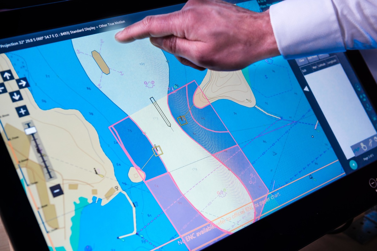
An electronic chart, also known as a digital chart or e-chart, is a digital representation of a traditional paper chart. It is designed to be viewed and utilized on electronic devices such as computers, tablets, or specialized chartplotting devices.
Electronic charts offer several advantages over their paper counterparts. One of the key benefits is their accuracy and ability to provide real-time updates. Electronic charts can be updated frequently to reflect changes in navigational data, such as shifting coastlines, new hazards, or updated depth soundings. This ensures that mariners have access to the most current and reliable information to navigate safely.
Another significant advantage of electronic charts is their storage and accessibility. Instead of physically storing and managing bulky paper charts, electronic charts can be conveniently stored in digital format. They can be accessed instantly and are easily searchable, allowing users to quickly find the specific chart they need. This saves space and reduces the risk of damage or loss associated with physical charts.
Electronic charts are also highly portable. They can be carried on small devices or stored in the cloud, making them accessible from anywhere with an internet connection. This mobility enables mariners to plan their routes and access critical information on the go, making navigation more efficient and flexible.
While there is an initial cost involved in acquiring electronic charts and the necessary devices or software, they are often more cost-effective in the long run. Updates to electronic charts are typically less expensive than purchasing new paper charts, and they eliminate the need for physical storage space and the frequent replacements required for worn-out or outdated paper charts.
Furthermore, electronic charts offer a range of charting functions that enhance navigation and situational awareness. They can display real-time vessel position, integrate with GPS systems to provide accurate positioning, create seamless chart overlays, and incorporate additional data layers such as weather information, navigational aids, and traffic patterns.
Personalization and user preferences are other advantages of electronic charts. Users can customize the appearance of the charts, adjust color schemes, choose which information layers to display, and zoom in or out to focus on specific areas of interest. This flexibility allows mariners to tailor the charts to their specific needs and preferences.
The use of electronic charts also improves workflow and efficiency. With the ability to quickly access and analyze information, mariners can make informed decisions more efficiently, saving time and reducing the risk of errors. Electronic charts also streamline chart updating processes, as new data can be seamlessly integrated and shared across devices.
Lastly, electronic charts contribute to environmental sustainability by reducing the need for paper production and waste associated with physical charts. By embracing digital alternatives, mariners can contribute to the conservation of natural resources and minimize their ecological footprint.
Accuracy and Updates
When it comes to accuracy and updates, electronic charts have a clear advantage over paper charts. Electronic charts can be easily and regularly updated to provide the most accurate and up-to-date information for navigation purposes.
Updates to electronic charts can be seamlessly integrated into the digital platform, ensuring that mariners have access to the latest information on changes in coastlines, new navigational dangers, updated depth soundings, and other relevant data. This real-time updating capability significantly improves navigational safety by keeping mariners informed of any changes that may affect their routes.
In contrast, paper charts rely on periodic updates and new editions. These updates can be time-consuming and costly, requiring mariners to purchase and replace entire charts or manually update the existing charts themselves. Without timely updates, mariners risk relying on outdated information, which can have serious consequences for navigation safety.
Electronic charts also offer the ability to receive alerts and notifications regarding critical updates. These notifications can be customized to specific areas or charts of interest, ensuring that mariners prioritize the most relevant information for their voyages. This proactive approach enables mariners to stay informed and take necessary precautions based on the latest data.
Additionally, the accuracy of electronic charts is augmented by the integration of other digital technologies. Electronic charting systems can be connected to GPS and navigational instruments, providing accurate positioning and real-time tracking. This integration further enhances navigation accuracy by eliminating manual chart plotting and allowing for precise positioning on the chart.
It is worth noting that the accuracy of electronic charts heavily depends on the quality and reliability of the data sources used to create and update them. Therefore, it is crucial for mariners to ensure that they are using reputable sources and regularly verifying the accuracy of the data provided by the electronic charts.
Storage and Accessibility
When it comes to the storage and accessibility of charts, electronic charts have a clear advantage over paper charts. With electronic charts, the need for physical storage space is eliminated as they are stored digitally. This not only saves physical space but also reduces the risk of damage, loss, or deterioration associated with handling paper charts.
Electronic charts can be conveniently stored on various devices or in cloud-based platforms. They can be accessed instantly from any location with an internet connection, allowing mariners to retrieve the charts they need without the hassle of searching through physical archives. This accessibility is particularly valuable for mariners who need to access charts while on the move or in remote locations.
Furthermore, electronic charts offer enhanced search functionality. Users can quickly search for specific charts, areas, or features, enabling them to find relevant information more efficiently. This saves valuable time and streamlines the chart retrieval process.
Electronic charts also allow for easy sharing and collaboration. Charts can be easily shared between devices or with other team members, facilitating seamless communication and coordination. This makes it easier for multiple users to access and work with the same charts, improving teamwork and efficiency.
In contrast, paper charts require physical storage space, which can be bulky and cumbersome. Managing and organizing a large collection of paper charts can be time-consuming and can pose challenges in terms of cataloging, indexing, and retrieving the needed chart when required.
Accessibility of paper charts also means physically locating and transporting the charts. This can be particularly challenging for mariners who need access to multiple charts on a regular basis or who require charts in different locations.
While conventional paper charts can be physically marked and annotated, electronic charts offer similar capabilities and more. Digital charting tools allow users to add notes, draw on the chart, and highlight specific areas of interest. These annotations can be easily modified or removed, giving users the flexibility to personalize and customize the charts according to their needs.
Overall, the storage and accessibility advantages of electronic charts make them a preferred choice for mariners who value convenience, efficiency, and the ability to access up-to-date charts anytime and anywhere.
Size and Portability
When it comes to size and portability, electronic charts have a significant advantage over paper charts. Digital charts are compact and can be carried on small electronic devices such as smartphones, tablets, or dedicated chartplotting devices. This allows mariners to have access to a wide range of charts without the need for physical storage or carrying around bulky paper charts.
Electronic charts can be easily stored and organized on digital devices or in cloud-based platforms, ensuring that mariners have a comprehensive collection of charts readily available. This portability enables mariners to plan their routes and access critical information on the go, which is especially valuable in situations where space is limited or when quick decision-making is required.
Furthermore, the size of electronic charts can be adjusted to fit the screen size of the viewing device. Users can zoom in or out to focus on specific areas or details, providing a flexible and tailored viewing experience. This versatility allows mariners to examine charts in finer detail or get an overview of a wider area without the limitations of a fixed paper chart size.
In contrast, paper charts are typically larger in size, especially when dealing with detailed charts covering vast areas. The large dimensions of paper charts can make them difficult to handle on board vessels or in limited workspace environments. They require adequate storage space and can be challenging to fold and unfold, increasing the risk of damage or wear and tear.
Additionally, paper charts are not as easily adaptable to changing circumstances or new information. With electronic charts, updates and revisions can be quickly incorporated, providing mariners with the most up-to-date information. On the other hand, updating paper charts can be time-consuming, involving manual correction or replacement of entire charts.
The size and portability advantage of electronic charts also has implications for sharing and collaboration. Digital charts can be easily shared between devices or via online platforms, allowing multiple users to access and work with the same charts simultaneously. This facilitates seamless communication and coordination among team members, making it easier to plan routes, share information, and make collaborative decisions.
Cost
Cost is a significant factor to consider when comparing paper charts to electronic charts. While there is an initial investment involved in acquiring electronic charts and the necessary devices or software, they can often be more cost-effective in the long run.
One of the main cost-saving aspects of electronic charts is the ability to update them at a lower cost compared to purchasing new paper charts. Updates to electronic charts can be easily obtained and applied digitally, usually at a fraction of the cost of buying a new paper chart. This is particularly beneficial in areas where navigational data frequently changes, as mariners can have access to the most up-to-date information without incurring significant expenses.
Furthermore, electronic charts eliminate the need for physical storage space, which can be costly, especially for organizations or individuals with extensive chart collections. Storing paper charts requires proper facilities, such as climate-controlled environments to prevent deterioration, and space to house large chart cabinets or racks. The cost of maintaining and organizing physical chart libraries can add up over time.
With electronic charts, storage is streamlined and does not require physical space beyond the digital devices or cloud storage utilized. This not only reduces the cost of storage but also contributes to better organization and easier accessibility of charts.
Additionally, electronic charts can offer additional cost savings in terms of chart maintenance. Paper charts can suffer from wear and tear, resulting in the need for replacement due to damage or fading details over time. Electronic charts, on the other hand, do not degrade in quality and can be used indefinitely, as long as the devices or software used to access them are functional.
While there may be upfront costs associated with purchasing the necessary devices or software to access electronic charts, these costs have decreased over time as technology has become more accessible. There are now a variety of electronic charting options available at different price points, allowing mariners to choose a solution that best fits their budget and needs.
It is important to note that the cost of electronic charts can vary depending on factors such as chart provider, coverage area, and additional features or data layers. Therefore, it is advisable for mariners to carefully consider their requirements and compare pricing options to ensure they are getting the best value for their investment.
Charting Functions
One of the key advantages of electronic charts over paper charts is the wide range of charting functions they offer. Electronic charting systems provide a host of features and capabilities that enhance navigation and situational awareness for mariners.
One important function of electronic charts is the display of real-time vessel position. By integrating with GPS systems or other navigational instruments, electronic charts can accurately track the position of the vessel on the chart, allowing mariners to precisely monitor their location and progress.
In addition to vessel tracking, electronic charts can incorporate a variety of data layers and overlays. These layers can include information such as weather data, sea conditions, tide and current information, traffic patterns, and navigational aids. By visualizing these additional data layers on the chart, mariners can have a comprehensive understanding of the surrounding environment and make more informed decisions.
Furthermore, electronic charts allow for the creation of seamless chart overlays. Mariners can overlay multiple charts to create a larger, composite chart, providing a broader view of a specific area or an entire route. This capability enables mariners to have a more holistic perspective and better plan their navigation.
Electronic charting systems also offer the ability to measure distances, depths, and other parameters directly on the chart. This feature eliminates the need for manual calculations and provides accurate readings for route planning or assessing potential hazards.
Another beneficial function of electronic charts is the ability to create waypoints, routes, and tracks. Mariners can mark specific locations on the chart as waypoints, plan routes by connecting these waypoints, and record tracks as a visual history of their voyage. This allows for efficient route planning and tracking of vessel movements over time.
Electronic charts often come equipped with advanced search and query capabilities. Mariners can quickly search for specific features, points of interest, or data attributes on the chart, making it easier to locate critical information. This functionality saves time and enhances efficiency during navigation.
Furthermore, electronic charting systems can provide automatic alerts and notifications to mariners based on predefined parameters. These alerts can include warnings for approaching hazards, deviations from planned routes, or changing weather conditions. By receiving timely alerts, mariners can take appropriate actions to ensure the safety of their vessel and crew.
Overall, the multitude of charting functions offered by electronic charts significantly enhance navigation capabilities, situational awareness, and decision-making for mariners. The ability to access and utilize these functions in real-time contributes to safer and more efficient voyages.
Personalization and User Preferences
Electronic charts allow for a high degree of personalization and customization, catering to the individual preferences and needs of mariners. This level of flexibility is one of the key advantages of electronic charts over traditional paper charts.
With electronic charts, users have the ability to customize the appearance and display settings of the charts. They can choose different color schemes, adjust brightness or contrast, and modify the level of detail shown on the chart. This customization option allows mariners to tailor the chart to their visual preferences, making it more comfortable and easier to interpret.
Electronic charts often offer the option to toggle different information layers on or off. Users can choose which elements they want to display on the chart, such as navigational aids, hazards, or charted features. This enables mariners to focus on the specific information they need for their current situation or route, decluttering the view and reducing distractions.
The ability to zoom in or out on electronic charts is another important feature for personalization. Mariners can zoom in for a more detailed view of a specific area, enabling them to examine important features or check for potential hazards. On the other hand, they can zoom out to get a broader overview of a larger area to plan their route or assess the surrounding environment.
Electronic charts also allow for annotations and markups. Users can add notes, draw on the chart, or highlight specific areas of interest. These annotations can be easily modified or removed as needed. The flexibility of annotating charts digitally eliminates the need for manual markings on paper charts and provides a more organized and editable way of making personal notes or keeping track of important information.
User preferences for chart orientation can also be accommodated with electronic charts. Users can select between different chart orientations, such as north-up, course-up, or heading-up, depending on their personal preference and navigational style. Mariners can choose the orientation that best suits their navigation habits and enhances their situational awareness.
In addition to personalization options, modern electronic charting systems often allow for user profile settings. Users can create and save their preferred settings, including display preferences and custom layers, as individual profiles. This enables mariners to easily switch between different profiles based on specific requirements or different navigational scenarios.
The ability to personalize and customize electronic charts ensures that mariners can work with charts that align with their individual preferences, enhance their efficiency, and suit their navigation style. This level of personalization contributes to a more personalized and optimized navigational experience.
Workflow and Efficiency
Electronic charts have revolutionized workflow and efficiency in the field of navigation. By streamlining processes and leveraging advanced technologies, electronic charts offer numerous advantages over traditional paper charts.
One of the key benefits of electronic charts is the ability to quickly and efficiently access information. With just a few clicks or taps, mariners can retrieve the desired chart, zoom in on specific areas, and access relevant navigational data. This eliminates the time-consuming process of searching through physical chart collections, unfolding large paper charts, and manually plotting positions.
Electronic charts also enable the seamless integration of other navigational tools and systems. These integrations can include GPS, radar, Automatic Identification System (AIS), and Electronic Chart Display and Information System (ECDIS). By connecting these systems with electronic charts, mariners can centralize and automate the collection and display of critical data, leading to a more efficient navigation process.
Furthermore, electronic charts facilitate automated route planning and optimization. Advanced electronic charting systems can analyze various factors, such as vessel characteristics, weather conditions, tide and current data, and navigational constraints, to suggest optimal routes for the vessel. This automation eliminates the time and effort required to manually plan and optimize routes, reducing the potential for human errors and enhancing overall efficiency.
Real-time updates are another significant advantage of electronic charts. As electronic charts can be easily updated with the latest navigational information, mariners have access to the most current and accurate data. This ensures that decision-making is based on the most up-to-date information, reducing the risk of encountering unexpected hazards or navigational challenges.
Electronic charts also simplify the sharing and collaboration of chart information. Multiple users can access and work with the same chart simultaneously, providing real-time information sharing and enabling effective collaboration. This enhances teamwork and contributes to better decision-making, particularly in scenarios where multiple stakeholders are involved in navigation and voyage planning.
Electronic charts further contribute to workflow and efficiency through features such as automatic alerting and notifications. For example, electronic charting systems can generate alerts for approaching hazards, deviations from planned routes, or changing weather conditions. These notifications help mariners stay informed and promptly respond to potential risks, improving safety and efficiency in navigation.
Overall, electronic charts optimize workflow and enhance efficiency in various aspects of navigation. By offering easy access to information, integrating with other navigational tools, providing real-time updates, enabling collaboration, and automating processes, electronic charts streamline operations and ensure a more efficient and effective navigation experience.
Environmental Impact
The adoption of electronic charts in place of traditional paper charts contributes to a positive environmental impact. Electronic charts offer several sustainability benefits over their paper counterparts, making them a greener choice for navigation.
One significant environmental advantage of electronic charts is the reduction in paper consumption. Paper charts require significant amounts of paper to produce, which contributes to deforestation and the depletion of natural resources. By transitioning to digital charts, mariners can help reduce the demand for paper and minimize the environmental impact associated with its production and disposal.
Electronic charts also help minimize waste generation. Paper charts may require regular updates or replacements, resulting in discarded and outdated charts. In contrast, electronic charts can be easily updated digitally, without the need to discard the entire chart. This reduces the volume of waste generated and promotes sustainable waste management practices.
Moreover, electronic charts eliminate the need for physical storage space. Storing paper charts often requires dedicated cabinets or racks, which occupy significant space on vessels or in offices. By embracing electronic charts, mariners can free up storage space or utilize it for other purposes, reducing the carbon footprint associated with constructing and maintaining storage facilities.
Transportation is another aspect where electronic charts contribute to environmental sustainability. Physical distribution of paper charts involves transportation by land, sea, or air, which consumes energy and emits greenhouse gases. In contrast, electronic charts can be distributed digitally, eliminating the need for physical transportation and reducing carbon emissions associated with logistics.
Furthermore, the longevity and durability of electronic charts contribute to their environmental benefits. Unlike paper charts that can deteriorate over time, electronic charts do not degrade in quality. As long as the electronic devices or software used to access them are functional, electronic charts can be used indefinitely. This reduces the need for frequent replacements and extends the lifespan of the charting materials.
Electronic charts are also aligned with the principles of digitization and digital transformation, which promote the reduction of unnecessary paperwork and physical documentation. By transitioning to digital charts, mariners can embrace a more streamlined and efficient approach to navigation, reducing the use of paper and the associated environmental burdens.
Overall, the adoption of electronic charts in navigation contributes to a more sustainable and environmentally friendly approach. By reducing paper consumption, minimizing waste, optimizing storage space, minimizing transportation, and promoting digital practices, electronic charts help mitigate the environmental impact associated with traditional paper charts.